Urban Tides
Overview
 Capture the Future of Our Urban Ocean!
USC Sea Grant’s Urban Tides Program invites individuals to visit the Southern California coast during extreme tide events and to take photos of the changing shoreline and any impacts on beaches or nearby communities. Extreme tides, particularly king tides, can help us identify current flooding hotspots and visualize what future sea level rise will look like for our coastline. Photos of these events help fill gaps in documenting coastal issues as well as identify areas of concern to assist in local planning and policy efforts.
How to Participate
- Pick a beach location to visit.
- Stay up-to-date on local extreme tide events by checking our tides calendar here.
- Before you go, review our photo-taking instructions and options on how to submit your photos below. You may also download or print our guidelines here.
- Consider attending one of our guided beach walks (temporarily suspended due to COVID-19).
- Download or view our printable maps and instructions to help guide how to easily access beaches nearest you and participate in the program. Each map is split up by geographic areas ranging from Malibu to Long Beach. The locations include Malibu to Point Dume, Malibu Lagoon to Venice, Marina del Rey to Dockweiler, Manhattan Beach to Torrance, Palos Verdes to San Pedro, and Long Beach. Each map includes directions to the beaches as well as the desired orientation for photos and accessibility.
Urban Tide Guidance and Maps
Explore the printable guidelines and maps below.
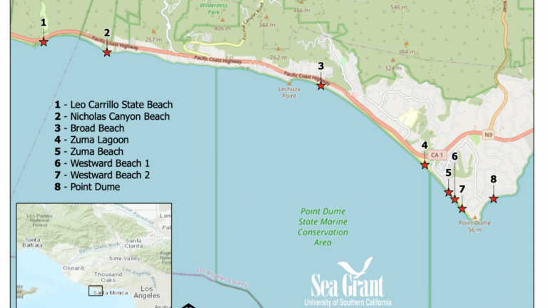
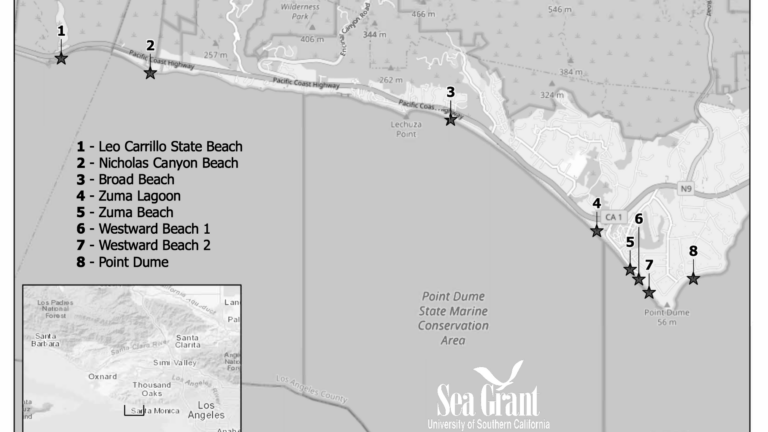

Photo-Taking Instructions
-
Please make sure to have location services turned ON for your camera!
- Choose a safe area to stand when taking your photo. Be aware of slippery areas, extreme waves, incoming tides and changing weather conditions. Don’t turn your back on the water. Cliffs and bluffs can become unstable, causing sudden erosion or slides.
- To take a photo, (1) find the highest water line in the sand (2) take two steps landward, and (3) stand parallel to the shoreline. You are able to retake your photo, if needed.
- The best time to take a photo is after a large wave, as the wave reaches the shore.
- Include a structure like a lifeguard tower, jetty, or pier to better help us analyze the waterline.
- Fill the survey out in the same location that you took the photo. If possible, submit it within the same day.
- Seeing changes over time is useful. Consider returning to your location at a future date.
How to Submit Photos


You can upload photos 3 ways: (1) the free Survey 123 app, (2) accessing the web link on your phone or (3) accessing the web link on your computer. Instructions for each of these three methods are listed below. Don’t forget to review our guidelines for taking and submitting a photo!
1. Via the free Survey 123 app
- Download the free Survey 123 app from your app store (for iPhone or Android) and then exit the app. (No account is required)
- From your phone’s browser, go to bit.ly/UrbanTidesSurvey.
- Select “Open in Survey 123 field app” from the option screen.
- IMPORTANT: Before the app launches, it will ask you to allow access to your location while in use. Select “Allow”.
- After you’ve launched the form for the first time, you’ll be able to access it by simply opening the Survey123 app on your phone. Select “Collect” to launch the form.
- Upload your photo(s), complete your observations and submit the form by tapping the checkmark at the bottom of the screen. Repeat steps for each observation you want to upload.
2. Use the web link via your smartphone
- Go to bit.ly/UrbanTidesSurvey (It is recommended that you open this link in your browser before going to the coast to avoid connectivity issues).
- Select “Open in Browser” from the option screen. You can then close the screen, leaving the form in the browser.
- Upload your photo(s), complete your observations and submit the form by tapping the checkmark at the bottom of the screen. Repeat steps for each observation you want to upload.
3. Use the web link via your computer
- Before heading to the beach, print the survey form here and take it with you. Don’t forget a pen!
- Write down your observations for each photo you take (use a new form for each location).
- When back at a computer, follow the directions from #2 above to open the survey link and submit your photos. Note: Since you are submitting photos at a later time, make sure to use the arrow when selecting your location, rather than the target, otherwise it will select your computer’s location.
About Urban Tides
Urban Tides is a community science effort launched by USC Sea Grant in 2015 to document tidal lines, beach erosion, coastal flooding, and other changing coastal conditions. USC Sea Grant’s Urban Tides initiative supports the broader efforts of the California King Tides Project.
Objectives of Urban Tides:
- Collect images to visualize current flooding and erosion risks and other shoreline changes at coastal locations in Southern California
- Connect the images and observations with scientists, community, and city leaders working on climate adaptation efforts.
- Engage communities in meaningful science and invite them more effectively into the discussion of how we can adapt to rising seas.
- Increase ocean and climate literacy within our communities.
Explore More About Urban Tides
2015 Urban Tide Photo Contest
Local community members captured the future of our Urban Ocean. Click the image below to view a gallery of photo submissions from this contest.

Contact Us
Stay Connected
Join our mailing list to receive USC Sea Grant’s monthly Urban Mariner e-newsletter, as well as periodic information on funding and fellowship opportunities, AdaptLA, and our Urban Tides Initiative.
USC Sea Grant
University of Southern California Sea Grant
3454 Trousdale Pkwy, CAS 200
Los Angeles, CA 90089-0153
(213) 740-1961
seagrant@usc.edu
For More Information
If you’re looking for something and can’t find it, please don’t hesitate to contact us.