What triggered Nepal’s catastrophic 2021 flood – and could it happen again?
Key findings:
Heavy monsoon rainfall, excessive snowmelt and unstable terrain combined to cause the 2021 Melamchi Valley flood disaster in Nepal, according to new USC Dornsife research.
The findings highlight how a mix of climate and geological factors intensify disaster risks.
The study also shows the value of using high-resolution satellite imagery and digital models of Earth’s surface to map landscape changes, create early-warning systems and improve flood preparedness, especially in remote areas.
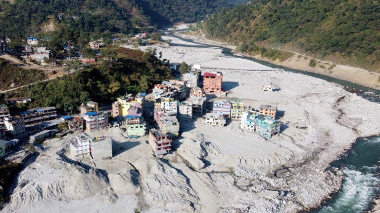
In late September and early October this year, unusually heavy monsoon rains led to deadly flooding and landslides in Nepal’s southern Kathmandu region. The disaster comes just over three years after a similar catastrophic event in the country’s Melamchi Valley, when devastating floods sent rocks, trees and mudflows sweeping through the valley, displacing thousands and wreaking havoc on local communities.
Using sophisticated technology, researchers have now evaluated the June 2021 Melamchi flood’s impact with remarkable precision and developed insights that could help predict — and perhaps prevent — future catastrophic floods.
Led by Josh West, professor of Earth sciences and environmental studies, and PhD student Chan-Mao Chen, both at the USC Dornsife College of Letters, Arts and Sciences, the study, published in Nature Geoscience, provides a detailed analysis of the flood’s triggers by combining cutting-edge satellite imagery, digital models of the valley’s landscape and field data. This approach allowed the researchers to investigate how rainfall, snowmelt and steep terrain worked together to unleash the powerful flood.
Perfect storm for flooding and debris flows

The study reveals that the Melamchi flood arose from a convergence of factors that set the stage for disaster.
“We know that climate change is intensifying the frequency and severity of extreme weather events, and this flood is a textbook example of how multiple forces can come together to create catastrophic flooding,” West said.
Researchers found that unusually heavy monsoon rainfall combined with excessive snowmelt in the higher reaches of the valley, overwhelming the region’s river systems.
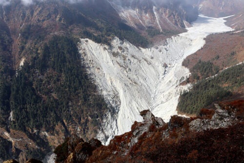
“The heavy rainfall triggered the snowmelt. This compounded the flooding and ultimately caused landslides,” Chen said. Steep topography and unstable slopes in the area worsened the flooding, he added.
Digital models of a disastrous flood
The team mapped changes in the landscape before and after the flood with unprecedented precision by analyzing high-resolution satellite imagery collected over a decade. They then employed sophisticated software to create highly detailed 3D maps called digital surface models (DSMs) of the area.
By analyzing the DSMs, they identified significant patterns of erosion and sediment deposits in the valley — key indicators of the flood’s destructive power.
“Traditional methods of monitoring floods rely on gauges and field observations, but these are limited in remote or hard-to-reach areas,” said Chen. “With the satellite imagery, we gained a much more complete picture of how the landscape was transformed by the flood.”
The DSMs allowed the researchers to estimate the scale of erosion and deposition, which is critical for understanding the severity of the flood’s impact on the landscape and local infrastructure, West said.
In some areas, the landscape had been altered so drastically that entire sections of the riverbed were reshaped.
In addition, the team examined boulders in the riverbed to estimate the power of the flood. By measuring the size and movement of these massive rocks, they were able to calculate how much water was needed to move them, providing insights into the flood’s transport capacity.
“We could tell how much energy the flood had and what it would take to move the debris,” Chen explained.
Global implications for flood policy and preparedness
The study’s findings have far-reaching implications for disaster management and policymaking in Nepal and similar regions around the world.
“Detailed flood analysis like ours is important for designing early-warning systems,” said West. Better understanding of the factors that trigger these kinds of flood events can help authorities predict when and where the next event might occur.
The researchers also emphasized the importance of using this data to inform land use and infrastructure planning. Flood-prone areas need to be mapped and understood, not just for current risk, but for how those risks will evolve in the future as the climate continues to change, Chen said.
For the public, the study reinforces the need for greater awareness of flood risks in vulnerable regions, especially in mountainous areas and locations where wildfires have scorched the earth and rapid changes in weather can have dramatic effects.
As the planet continues to warm and extreme weather events become more frequent, the study provides valuable insights into how scientists can better predict and mitigate the effects of floods and other natural disasters.
“Floods like the one in Melamchi Valley could become more common as climate change intensifies,” said West. He and Chen hope their study and others like it can reduce the risks involved and save lives in the future.
Editor’s Note: Darrin S. Joy contributed to this article.