What causes mudslides and floods after wildfires? Hint: It’s not what scientists thought
Key points:
Scientists once assumed that flooding and mudslides after wildfires were linked to the waxy coating that builds up on charred soil, preventing water absorption.
USC Dornsife researchers found that water flow came from absorbed water in both burnt and unburnt areas, suggesting that water was, in fact, being absorbed into burnt ground.
The discovery provides valuable insights into where and when potential flooding and mudslides may occur and how landscapes recover after a wildfire.
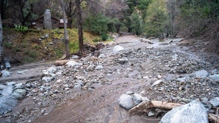
In 2020, one of the largest wildfires in Los Angeles County raged across the San Gabriel Mountains, scorching more than 115,000 acres, damaging or destroying over 150 structures and raining ash and smoke down on pandemic-weary Angelenos.
But even after exhausted firefighters had finally snuffed out the flames, the Bobcat Fire — like other so-called “mega-fires” that have become more common due to climate change — carried the potential to wreak more havoc in its wake. As rainstorms deluge burnt areas, flooding, mudslides and debris flow can compound the fire’s damage.
Understanding how water accumulates and monitoring the movement of runoff and streamflow in burn areas helps authorities predict when and where these post-wildfire events might occur so they can provide affected residents with early warning of flash flooding and debris movement.
Common knowledge has long held that loss of vegetation during a fire leaves soil vulnerable to erosion because the plant roots that hold the soil in place wither and die. Scientists, however, have long held a different view, that as leaves burn, their waxy coating forms an organic, oily substance on the soil’s surface. This waxy coating creates a water-repellant layer at or near the surface. Scientists believed this layer prevented the ground from absorbing water, resulting in rapid water runoff akin to a Slip ‘N Slide that carries mud and debris.
New research published in Nature Communications has called that scientific theory into question.
A watershed finding
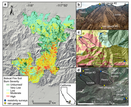
Scientists at the USC Dornsife College of Letters, Arts and Science, in collaboration with researchers from the University of Michigan, the U.S. Geological Survey and Rutgers University, monitored two wet seasons following the Bobcat Fire, from December 2020 to March 2022. The team concluded that water was, in fact, being absorbed by the burnt ground that contained this waxy coating.
Specifically, the team studied three watersheds — areas of land that drain rainfall and snowmelt into streams and rivers — in Southern California’s San Gabriel Mountains. Two of the watersheds burned during the 2020 Bobcat Fire and the other was mainly untouched.
The researchers found that post-wildfire, a significant portion of the water flow in all three watersheds came from water that had been absorbed in the ground.
Earth scientist Joshua West, who led the study at USC Dornsife, said it was no surprise that the flow of water and debris in the burned area’s stream was four to 10 times greater than the flow in the unburnt area’s stream. What he didn’t expect was that stormwater had permeated the ground in both of the burnt watersheds.
This finding contradicted scientists’ previous beliefs that little water would be absorbed in the burnt watershed due to the presence of waxy soils.
In the unburnt watershed, however, the researchers found that trees absorbed the water as anticipated, preventing it from reaching streams.
West and Earth sciences PhD candidate Abra Atwood surmised that, in keeping with the popular notion, increased water in rivers originated from the burnt areas because burned trees and vegetation could not retain water in their roots as they normally would, but not from the inability of the soil to absorb water.
The research team’s finding that the water-repellant layer does not prevent water from being absorbed into the soil strengthened their hypothesis that the water in streams comes from both rainfall and groundwater, leading to increased flooding in burnt areas versus unburnt.
Water build-up poses enduring threat
Identifying areas that are at high-risk for debris flow and mudslides and accurately predicting the amount of debris flow following rainfall in burn areas depends on understanding how water infiltrates the soil in different areas and how it contributes to the flow of streams.
Also, the dynamics of water flow and how water accumulates below the surface can significantly impact how quickly landscapes recover after a wildfire. This recovery affects the stability of hill slopes and helps buffer forests against severe drought.
On the flip side, water accumulation can contribute to landslides for up to four years after a fire as pressure builds up in the soil.
“The underground water accumulation suggests that the potential for landslides extends far beyond the two years following the fire, posing an enduring problem,” West said. “The abundance of water stored in areas affected by the Bobcat Fire, for example, could serve as a harbinger of future flooding concerns in the years to come.”
West is confident that the study’s findings hold important information that can be used by the USGS to improve burn area monitoring and predict flooding and mudslides after a wildfire.
About the study
Funding was provided USC Dornsife’s Department of Earth Sciences and the National Science Foundation.
Featured USC Dornsife faculty:
Joshua West, professor of Earth sciences and Environmental Studies