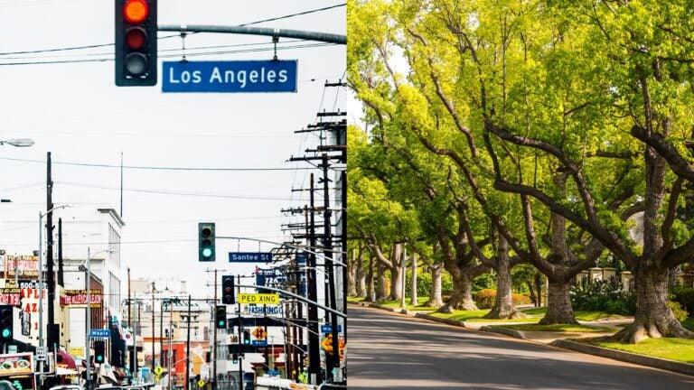
Study finds extreme temperature swings hit minority, low-income communities hardest
Key findings:
Large daily temperature swings are known to increase risk of mortality and morbidity.
Satellite data shows that 24-hour temperature swings are more extreme in minority and low-income communities than in affluent white communities across all 50 states.
Black and brown communities can be exposed to daily temperature variations that are as much as 21% greater than those impacting white communities.
Low-income populations can see temperature fluctuations that are up to 17% greater than those seen by higher-income populations.
The built environment, particularly in urban areas with fewer parks and urban trees and no proximity to bodies of water, drives wider daily temperature fluctuations.
Multiple studies show that low-income and minority communities bear the brunt of climate change. A new study by researchers at the USC Dornsife College of Letters Arts and Sciences now sheds light on another climate-related risk: daily temperature variation (DTV) and how it contributes to health inequalities in the U.S.

Previous research has linked large temperature swings throughout each 24-hour day to increased risk of illness and death — especially among the elderly and young children — as the body experiences stress due to rapid temperature changes that impact cardiovascular and respiratory health.
However, the effect of DTV on health inequality is less understood, particularly in the U.S.
Using satellite data, the USC Dornsife team found that minority and low-income communities experienced greater DTV than white communities across all 50 states.
“In general, scientists and researchers give a lot of attention to rising temperatures, heat waves and what’s called the ‘heat island effect,’ but not much attention has been paid to the fluctuation of temperature throughout a day,” said Emily Smith-Greenaway, professor of sociology and spatial sciences at USC Dornsife. “Our foundational work provides a broad stroke, a descriptive portrait, that touches on a new area of climate science emphasizing how erratic temperature can be, who it impacts the most, and how.”
The study, published May 21 in PNAS Nexus, examined three sociodemographic characteristics — race and ethnicity, income and age — to determine which populations in all 50 states and the District of Columbia are most vulnerable to large DTV.
Daily temperature variations impact some more than others
The researchers found that densely populated regions with limited green spaces, poor urban tree canopies and fewer bodies of water — areas which are often home to marginalized communities — had greater swings in temperature on average.
Co-author Shengjie Liu, a PhD candidate at USC Dornsife’s Spatial Sciences Institute and Smith-Greenaway found that in 10 states — California, Texas, Florida, New York, Pennsylvania, Illinois, Washington, Massachusetts, Connecticut and Rhode Island — Black communities experience temperature variations from 1.7 to 5.4 degrees Fahrenheit (0.93 to 3.01 degrees Celsius) greater than those in white communities, a difference of 7% to 21%.
This means Black and brown communities endure hotter temperatures at the hottest times of the day and colder temperatures during the coldest times, Liu explained.
The study also showed that people earning $15,000 per year or less experience daily temperature changes between 1% and 17% greater than those earning $200,000 per year or more.
The threat posed by temperature variations to these underrepresented communities is greater than the threat of heat islands, urbanized areas with higher temperatures than surrounding areas.
“The need for targeted mitigation strategies beyond those aimed at addressing heat waves must be factored into urban design to minimize wild temperature fluctuations,” Liu said.
A new effect of structural racism
Smith-Greenaway says the study findings reveal another way segregation, redlining and other forms of structural racism continue to harm marginalized communities. “Basically, we have a situation where, in any given city, the Black and brown populations are disproportionately living in the least favorable census tracts,” she said.
Rhode Island, for example, stood out as having the largest temperature variations from day to night. Providence, the state’s most populous city with the highest concentration of non-whites, had the largest DTV exposure. It also has the smallest green space infrastructure.
“This inequality in the built urban environment can be understood as a legacy of structural racism that undergirds persistent neighborhood segregation and housing that has led to inequalities in access to climatically healthy neighborhoods,” Smith-Greenaway said. “Historical redlining has led to racial and ethnic minorities living in areas with less green space, while white populations have occupied prime suburbs with better access since the 1950s,” she added.
Zooming in on DTV
For the current study, Liu and Smith-Greenaway worked with existing satellite data that provides daily observations at a one-square-kilometer spatial resolution, capturing the big picture over the entire U.S.
The researchers plan to work with higher-resolution data in the future, hoping they can reveal greater insights into how DTV affects communities at the neighborhood level.
Their work could provide data to help policymakers, city planners, developers and other officials design solutions to decrease temperature swings and reduce the threat to citizens.