As climate disparities divide LA, researchers aim to heal the scars of environmental injustice
![]()
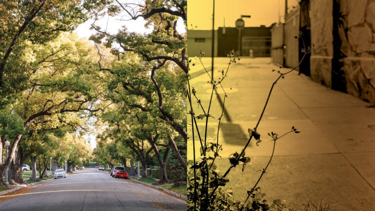
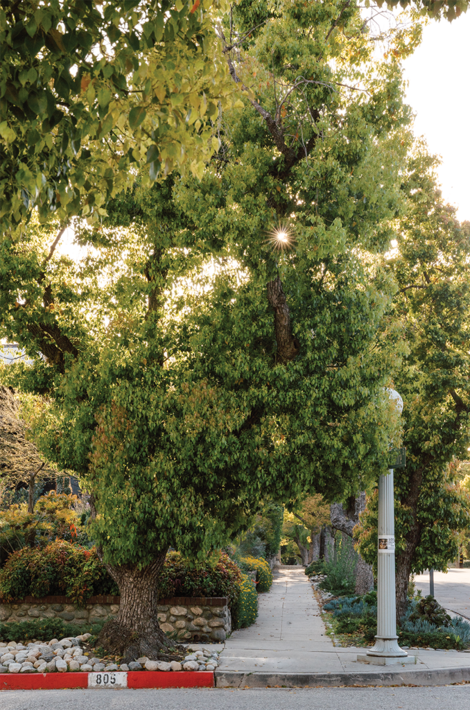
In Southern California, heat divides communities not by mere degrees — it creates different worlds. Here, in this region known for some of the nation’s most extreme temperatures, the experience of a hot day can vary dramatically from one neighborhood to another. Consider a summer afternoon in affluent, predominantly white, tree-lined Madison Heights in Pasadena, where ancient oaks cast cooling shade over elegant streets and filter pollutants, making the air feel surprisingly pleasant even when the mercury soars.
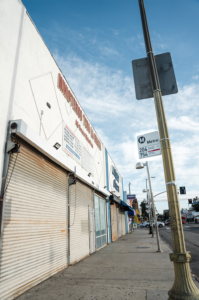
Contrast this with South Los Angeles, a mere 40-minute drive away, where the demographic shifts to predominantly Black and Latino residents. Park on Vermont Avenue, just south of USC’s University Park Campus, and you’re immediately struck by the stark landscape: Vast expanses of exposed asphalt absorb and radiate the sun’s intensity, making the air shimmer with heat. Here, the oppressive warmth is not just felt; it assaults you, underscoring a tale of two climates within a single metropolitan expanse.
“On the same day, with the exact same weather conditions, the experiences for communities across L.A. County can be tremendously different,” says Manuel Pastor, Distinguished Professor of Sociology and American Studies and Ethnicity and Turpanjian Chair in Civil Society and Social Change at USC Dornsife.
People of color and those with low incomes are more likely to live in neighborhoods without shade, notes Pastor, who leads USC Dornsife’s Equity Research Institute (ERI).
In neighborhoods such as East Hollywood, South L.A. and Pacoima, temperatures can soar up to 10 degrees higher than in more affluent and predominantly white areas nearby. This phenomenon, known as the “heat island effect,” worsens as the climate warms, putting residents of these areas at greater risk of heatstroke, heart attacks, strokes and other heat-related illnesses.
This disparity extends beyond just temperature. Take the impact of air pollution on people of color, who are more likely to live perilously close to freeways and toxic industries. The heightened exposure to pollutants puts them at greater risk of respiratory illnesses and lung cancer — and poses a particularly dire threat to children.
“The most significant and consistent predictor of higher exposure to air pollution is not income,” Pastor says. “It is race.”
Environmental Injustice
From the way toxins can interact with our genes in utero to a childhood spent next to a highway, researchers increasingly recognize the intricate relationship between our environment and our health. In USC Dornsife’s new Developmental Origins of Health and Disease program, run jointly with Children’s Hospital Los Angeles, graduate students work alongside faculty to investigate how factors outside the body — whether occurring in the environment, in society or across generations — can cause disease.
But finding solutions to close deeply rooted environmental equity gaps, and their interrelated causes, is far from straightforward. Paulina Oliva, associate professor of economics at USC Dornsife, is developing tools to help policymakers understand, at a granular scale, how air pollution affects communities in disparate ways.
She points out that residents of areas plagued by higher levels of air pollution often face a double jeopardy: Not only do they typically have limited access to health care, but they also lack the financial resources necessary for adequate recovery time from illnesses.
“If I get sick because of exposure to air pollution,” says Oliva, “I might be fine because I can stay home and take care of myself. But for a low-income person who can’t do that, their health could be disproportionately damaged.”
This intertwining of environmental harm with socioeconomic disparities presents a significant challenge for researchers. It complicates efforts to study the direct effects of pollution because the compounded impacts on less affluent communities are difficult to separate and analyze in isolation.
When it comes to reducing the environmental equity gap, what balance should policymakers strike between improving air quality and increasing access to health care? Oliva is developing tools to help policymakers break down the complex causes of environmental inequities, thereby supporting the creation of more effective interventions.
In neighborhoods such as East Hollywood, South L.A. and Pacoima, temperatures can soar up to 10 degrees higher than in more affluent and predominantly white areas nearby.
Data-Driven Urban Forestry
One solution to environmental inequity? Plant more trees. USC’s Urban Trees Initiative, launched in 2020 by USC Dornsife’s Public Exchange, aims to reduce environmental disparities across L.A. by helping the city and local nonprofits plant more trees in heat islands and pollution hotspots. In 2023, the Bezos Earth Fund awarded $2.9 million to Pastor and John Wilson, director of the USC Dornsife Spatial Sciences Institute (SSI) and professor of architecture, civil and environmental engineering, computer science, population and public health sciences, sociology and spatial sciences, to counter some of climate change’s negative impacts and to narrow existing environmental equity gaps plaguing cities across the United States.
Working as part of the USC Urban Trees Initiative, SSI is using geospatial tools and data analysis to determine which areas within vulnerable communities would most benefit from additional tree canopy.
Pastor and Wilson note that, thanks to the Bezos Earth Fund, they are planting the seeds of equity and resilience. Their work, a fusion of strategic tree-planting, advanced geospatial methods and social justice, isn’t just shaping urban landscapes, it’s enhancing community well-being.
Ask the trees and the community
Another key step? Understanding which trees to plant. William Berelson, Paxson H. Offield Professor in Coastal and Marine Systems, is part of the Urban Trees Initiative, collaborating with the City of Los Angeles to develop a scorecard that ranks trees according to how well they cool the streets and filter pollution.
“We go out and basically interrogate a tree,” says Berelson, professor of Earth sciences, environmental studies and spatial sciences. “We put a sensor in it and measure the canopy air quality to determine how effective it is under different conditions.”
Pastor’s work overlaps with the Urban Trees Initiative’s mission. For more than a decade, his team has worked with PolicyLink to develop the National Equity Atlas, America’s most comprehensive map of racial and economic equity. Today, ERI is expanding on this work by gathering data on environmental indicators and climate risk, including heat maps and tree canopy coverage, to pinpoint areas most in need of intervention.
At the forefront of Pastor’s mind, though, is finding ways to foster healthier environments while protecting communities from “green gentrification.” This, Pastor says, is why conversations with residents about their wants and needs are driving both the National Equity Atlas and the Urban Trees Initiative.
“A large part of our work is listening to environmental justice leaders throughout the United States,” says Pastor.
“We ask, ‘What would be a useful piece of data for environmental justice and health equity in your communities?’
“We are always conscious of the power and importance of community voices.”