A Bird’s Eye View
The passing troupe of blue-uniformed grade school children on a visit to University Park campus nudged each other and pointed at the sky as, 250 feet up in the air, a large white weather balloon sailed over Alumni Park.
On the ground, Darren Ruddell, director of undergraduate studies at USC Dornsife’s Spatial Sciences Institute (SSI) and students from his “Maps and Spatial Reasoning” class were monitoring the helium-filled balloon’s trajectory. Curious students and faculty spied the balloon and joined the group. Heads tipped back and eyes squinted skyward even after the small GoPro camera with a wide angle lens which Ruddell and his students had attached to the balloon had become a mere dot.
But despite its near invisibility on the ground, from its vantage point floating high above campus the camera was taking a photograph every two seconds using an automatic time lapse setting.
“It’s so exciting to finally see the balloon go up,” said Nicole Bosetti, a junior majoring in GeoDesign at USC Dornsife, a new bachelor’s of science degree launched this Fall by SSI. “We’ve been preparing for this event for two weeks.”
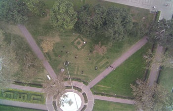
One of the aerial views of USC’s University Park campus taken at two-second intervals by an infrared camera attached to the weather balloon. Aerial images can be “knitted” together using computer technology to create mosaic maps. Photo courtesy of Darren Ruddell.
The balloon launch was one of many events across the globe celebrating GIS Day on Nov. 20. The annual event raises awareness of geographic information systems (GIS) by informing the public about mapping technologies and their practical applications. The event also reminded students of the new GeoDesign degree.
“Many problems we currently face as a society could reap huge benefits from spatial analysis,” said Ruddell, assistant professor (teaching) of spatial sciences.
“Thinking about things spatially enables us to make better decisions about how to design our cities and manage our resources more effectively. There is no societal challenge right now that would not benefit from spatial analysis.”
The new major trains students to find innovative solutions to these challenges, such as urban sustainability, precision agriculture, habitat restoration, environmental conservation, wildlife management, global warming, crime analysis, transportation planning and policy development. The first of its kind in the world, the degree provides students with valuable skills in design, planning, geographic information science and geospatial technologies so they can pursue professional careers and/or graduate study in one or more of these three fields as well as environmental areas.
The balloon launch raised awareness of the new degree, which is a joint project among USC Dornsife, the USC School of Architecture and the USC Sol Price School of Public Policy.
As the students brought the balloon back down to Earth by reeling in the kite string they had attached to it, Ruddell said the next step was to download the images captured by the camera onto a computer where they could be “knitted” together into a mosaic map. This technology can help users make spatially informed decisions in many areas, including disaster response, landscape architecture, transport planning, energy and inner city renewal.
“We can use spatial analysis to understand where would be the best areas to develop alternative transportation systems and where to implement redevelopment programs. We can target decaying buildings, revitalize them and create mixed use projects that incorporate transportation systems,” said Ruddell, noting that spatial analysis is currently being used by planners as they look at revitalizing downtown Los Angeles.
“GeoDesign enables us to look at the infrastructure of a city holistically so we can plan for the future while ensuring that all the different elements will work together effectively,” Ruddell said. “It helps us understand what our city looks like today and to plan what we would like it to look like in 10, 20 or 50 years. How can we make it a more efficient, resilient and enriching place for people to live?
“Spatial technology can help provide those answers. The risk of not using it is that we end up looking at our urban environment from an individual perspective — what is best for me, rather than what is best for the community.”
The balloon launch also provided students with a valuable research opportunity to do their own primary data collection, transfer it to the lab and then analyze it.
“Most of the data we use in spatial analysis, such as the U.S. census, is secondary data, meaning it is prepared by someone else,” Ruddell said. “This project enables students to experience the whole lifecycle of a project, understand factors, such as weather conditions, that might limit that process and reflect on the difference between primary and secondary data.”
Ruddell outlined how the project could be used by landscape architects.
“USC President Nikias has launched an initiative to increase green space on campus by 20 percent over the next few years. We could use this balloon to do a survey of the university’s land use and quantify the current amount of vegetation cover. We can then make spatially informed decisions on where we should add new plants, grass or trees to accomplish this goal.”
The project could also be used to formulate emergency evacuation plans, by working out the nearest campus exit points from particular buildings, Ruddell said.
Using aerial imagery, students could further use the data to study the spectral signatures of different surface properties found on campus, such as asphalt, vegetation or concrete. This could then be used to create a database of signature profiles showing the specific combinations of emitted, reflected or absorbed radiation at varying wavelengths, which can be used to identify a surface material.
“The energy demands of a building are directly related to the color and materials used for its roof,” Ruddell said. “We could test this hypothesis by using the camera to capture the imagery of different buildings on campus and then analyze their spectral signature and compare it to the actual energy load of the building. Are our findings consistent with what we find in the literature or are they different?”
Prior to the balloon launch, Ruddell, Emeritus Professor of Architecture Robert Harris, director of the master of landscape architecture program and former dean of the USC School of Architecture and Lavonna Lewis, director of the USC Sol Price School of Public Policy undergraduate program, presented the new GeoDesign degree to interested students and faculty.
“USC’s vision is to emphasize interdisciplinary collaboration and problem solving,” Ruddell said. “Our new GeoDesign degree epitomizes that spirit.”