Mapping a Better Future
The Spatial Sciences Institute housed at USC Dornsife continues to set new standards in the study of geospatial analysis with the launch this Fall of two new online graduate certificates in geographic information science and technology (GIST).
The Graduate Certificate in Geospatial Leadership and the Graduate Certificate in Geospatial Intelligence offer GIST professionals additional expertise in their field.
“Our geospatial leadership online program is designed for professionals with significant professional GIST experience who aspire to a leadership role within the field,” said John Wilson, director of the Spatial Sciences Institute, and professor of sociology, civil and environmental engineering, computer science and architecture.
“This graduate certificate is also designed for those already in a leadership role who want to expand their leadership skills and stay abreast of the most recent advances in the fields of GIScience and geospatial technologies.”
Providing emerging managers and executives in geospatial fields with the opportunity to strengthen their knowledge of selected geospatial technologies, the geospatial leadership program addresses the underlying scientific concepts and analytical methods involved. It then provides insight into ways they can be used in decision-making to direct geospatial information management organizations in a constantly changing environment.

Director of the Spatial Sciences Institute John Wilson, said the two new online graduate certificates are designed to help professionals advance in their geospatial careers. Photo by Geoffrey Kass.
The curriculum concludes with a capstone course, “The Practice of Geospatial Leadership,” which teaches the qualities and skills leaders need to help their geospatial information management groups and organizations achieve success. For their final project, students will also complete a life map and a series of self-assessments, culminating in a personal leadership development plan.
A signature component of the course is provided via an executive-style weekend workshop held just prior to the start of the annual Esri International User Conference in San Diego, California. The workshop provides students with the opportunity to work with three or more internationally recognized geospatial leaders from industry, the public sector, nongovernmental organizations and academe.
“The USC Spatial Sciences Institute is showing its leadership in the geospatial world by offering the first academic graduate program in geospatial leadership,” said David DiBiase, Esri education industry team lead.
“As a designated Esri Development Center, the USC Spatial Sciences Institute is one of a small number of university centers that Esri recognizes as having exemplary programs focused on educating students in ways that promote the design and development of GIS applications using Esri’s ArcGIS platform.”
The Graduate Certificate in Geospatial Intelligence provides education and training in the scientific concepts, analytical methods and core geospatial technologies used to address a wide range of human security issues worldwide. These include natural disasters, humanitarian crises, environmental risks, military operations, terrorist attacks, genocide, political violence, public health issues and food/resource accessibility challenges.
“The geospatial intelligence online program is designed for those already working in geographic intelligence fields, such as disaster response, environmental change, business or national security,” Wilson said. “It’s also for those who recognize the value that geographic intelligence skills would have in their current work in such areas as intelligence problem solving and the environment.”
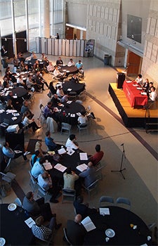
Students, alumni and faculty from geographic information systems and geography academic programs throughout Southern California joined industry professionals at the 2014 Los Angeles Geospatial Summit, an annual event presented by USC Dornsife’s Spatial Sciences Institute each February. Photo by Rachel Kornack.
R. Maxwell Baber, director of academic programs for the United States Geospatial Intelligence Foundation (USGIF) said, “The United States Geospatial Intelligence Foundation sees a growing demand for professional and advanced education in geospatial intelligence, and we are excited that the USC Spatial Sciences Institute, a valued member of the USGIF, is offering a graduate certificate in geospatial intelligence.”
The course is designed to develop critical thinking, collaboration and communication skills. Upon its completion, students will understand surveillance, targeting and navigation needs; they will be able to design and implement strategies for capturing or sourcing geospatial data and any accompanying metadata; and critically evaluate potential impacts of data quality on spatial analysis and decision making. Students will have also mastered the theory and protocols of radar interpretation, infrared and multi-spectral imagery, full motion video, legacy maps, digital geospatial datasets and social media feeds, and will be able to prepare and present intelligence reports tailored to a variety of human security applications.
The program concludes with the capstone course “Geospatial Intelligence Tradecraft,” which covers typical geospatial intelligence tasks and their use in military operations, national and homeland security, international relief work and disaster management.
Full-time students can complete each certificate in two semesters. The programs are offered throughout the year in Fall, Spring and Summer semesters. The Geospatial Intelligence Graduate Certificate applies towards the USC online Masters of Science in Geographic Information Science and Technology, making this certificate a viable stepping stone towards obtaining the GIST master’s degree.
“Both of these certificates are designed to leverage the professional experiences that individuals bring to the programs,” Wilson said. “By coupling this with the fundamental science that governs the acquisition, organization, analysis, modeling, visualization and interpretation of geographic information, and the accompanying geospatial technologies that enable its application, these programs will propel professionals to advance in their geospatial careers.”
For more information on these new certificates and the GIST online graduate programs, visit gis.usc.edu or call (888) 907-5029.