‘Mercury bomb’ threatens millions as Arctic temperatures rise
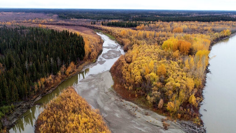
The Yukon River flows west across Alaska toward the Bering Sea, eroding Arctic permafrost along its banks and transporting sediment downstream. Within that sediment lurks a toxic stowaway: mercury.
As the Arctic warms with climate change, heating up to four times faster than the global average, mercury sequestered in the permafrost for millennia is being eroded by rivers and released into the environment.
In a study published today, researchers at the USC Dornsife College of Letters, Arts and Sciences introduce a more accurate method to measure the amount of mercury released from permafrost by the river and estimate the total mercury awaiting release.
The toxic metal poses an environmental and health threat to the 5 million people living in the Arctic zone, more than 3 million of whom live in areas where permafrost is expected to vanish altogether by 2050.
“There could be this giant mercury bomb in the Arctic waiting to explode,” says study co-author Josh West, professor of Earth sciences and environmental studies at USC Dornsife.
Mercury moves from air to ground to water
The planet’s natural atmospheric circulation tends to move pollutants toward high latitudes, which results in mercury accumulation in the Arctic, explains West. “Because of the way it behaves chemically, a lot of mercury pollution ends up in the Arctic. Permafrost has accumulated so much mercury that it could dwarf the amount in the oceans, soils, atmosphere and biosphere combined,” he said.
In the Arctic, plants absorb mercury, then die and become part of the soil, which eventually freezes into permafrost. Over thousands of years, mercury concentrations build up in the frozen soil until it thaws, an increasingly common occurrence due to climate change.
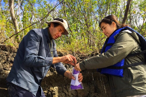
The research team, which includes collaborators from Caltech, the Yukon River Inter-Tribal Watershed Council, MIT, and Delft University of Technology in Netherlands, focused their study around two northern villages in Alaska’s Yukon River Basin: Beaver, located about 100 miles north of Fairbanks; and Huslia, 250 miles west of Beaver.
Previous methods of estimating mercury levels, which used core samples from the top three meters (about 10 feet) of permafrost, varied up to fourfold and faced limitations due to the sampling depth.
Seeking greater accuracy, the USC Dornsife-led team analyzed mercury in sediments in riverbanks and sandbars, tapping into deeper soil layers. “The river can quickly mobilize large amounts of sediment containing mercury,” said Isabel Smith, a doctoral candidate at USC Dornsife and the study’s corresponding author.
The researchers found that mercury levels in sediments were consistent with the higher estimates from previous studies, confirming that sediment samples provide a reliable measure of mercury content and offer deeper insight into the permafrost’s hidden dangers.
Also, the team used remote sensing data from satellites to monitor how fast the Yukon River alters course, a process that occurs naturally over time. These changes in the river’s path make a difference because they affect how much the waters erode mercury-laden sediments from riverbanks and deposit them along sandbars. Understanding these dynamic shifts helps researchers predict the movement of mercury.
Interestingly, sediments with finer grains contained more mercury than those with coarse grains, suggesting some soil types may pose greater risks than others.
“Taking into account all of these factors should give us a more accurate estimate of the total mercury that could be released as permafrost continues to melt over the next few decades,” Smith said.
How much havoc could mercury wreak?
While the environmental mercury released from melting permafrost doesn’t pose an acute toxic threat today, its effects build over time. Exposure increases as the metal accumulates in the food chain, especially through fish and game that humans consume.
West notes that risk of contamination through drinking water is minimal. “We’re not facing a situation like Flint, Michigan,” he says. “Most human exposure to mercury comes through diet.”
The researchers also emphasize that even though the river erodes banks and mobilizes mercury-laden sediments, it also redeposits those sediments on sand bars and on beaches along the banks.
“There’s another layer of complexity here,” West says. “The rivers are reburying a considerable amount of the mercury. To really get a handle on how much of a threat the mercury poses, we have to understand both the erosion and reburial processes.”
Still, the long-term effects could be devastating, particularly for Arctic communities dependent on hunting and fishing.
“Decades of exposure, especially with increasing levels as more mercury is released, could take a huge toll on the environment and the health of those living in these areas,” Smith said.
The researchers say they hope the tools they’ve developed will enable a more precise assessment of the “mercury bomb,” in hopes it might be diffused.
About the study
Additional authors on the study include Emily Seelen at USC Dornsife; Yutian Ke, Emily Geyman, Jocelyn Reahl, John Magyar, Woodward Fischer and Michael Lamb at Caltech; Madison Douglas at Caltech and MIT; Kieran Dunne at Caltech and Delft University; and Edda Mutter at the Yukon River Inter-Tribal Watershed Council.
This study was supported by National Science Foundation grants 2127442, 2127444 and 2127445, the Geological Society of America, and the Resnick Sustainability Institute at Caltech.