
C HRIS ANDREWS
VP of Platform Integrations with the Cesium team, Bentley Systems
Chris supports partners and customers who are creating impactful experiences by integrating open geospatial technology into their products and workflows.
Previously, Chris was COO at Rendered.ai, led a team at Esri focused on 3D, Defense, Urban Planning, and AEC products, and was the lead product manager for Autodesk’s InfraWorks.
 DAVE BERNSTEIN, CH, PLS GISP
Vice President of Hydrospatial Operations, NV5 Geospatial
Dave Bernstein is the Vice President of Hydrospatial Operations at NV5, with over 25 years of experience providing management, oversight and support to all aspects of hydrographic solutions. With formal education and training in Marine Geology, GIS and Hydrography, and a diverse record of practice, he manages the technical, operations, and strategy of hydrographic surveys from inland, nearshore and offshore waters. He holds a B.A. degree in Environmental Geoscience and GIS, and an M.S. in Marine Geology. Dave has a PLS license in North Carolina and is also a Certified GIS Professional (GISP), and an ACSM Certified Hydrographic Surveyor (CH). He is on the ACSM-THSOA Hydrographer Certification Board and is active in education, outreach, and career development of the hydrographic community.
MICAH BRACHMAN, Ph.D.
Community Manager, Open Geospatial Consortium (OGC)
Micah Brachman, Ph.D., has blended his lifelong passion for maps with a distinguished career in geospatial data science, leveraging his expertise across academic, government, non-profit, and corporate sectors. As a geographer, Micah has developed a skill set encompassing GIS, remote sensing, statistical modeling, and machine learning. Currently, Micah is a Community Manager at the Open Geospatial Consortium (OGC), where he serves as the Director of Interoperability Certification, Architect of the Climate and Disaster Resilience Pilot, and supports nearly 100 technical working groups. His role involves enhancing collaboration among over 500 organizations to improve the interoperability of geospatial technologies. Previously, Micah was a Data Scientist at AppFolio, Inc., where he developed and deployed predictive models in R and Python, enhancing business insights and advanced analytics. He also served as a Lecturer at the University of Maryland, designing courses focused on Geospatial Intelligence and training the next generation of geospatial professionals. Micah earned his PhD in Geography from UC Santa Barbara, specializing in transportation, emergency management, and spatial optimization. His extensive experience in the geospatial sciences positions him at the forefront of advancing the global interoperability of geospatial data and technology.
 CORA CHONG
GIS Specialist, CBRE
Cora Chong is a GIS Specialist on the Innovation team within the Location Intelligence group at CBRE, a global real estate services company. Her work focuses on spatial consulting for high-value, high-profile commercial real estate projects, which may include adaptive reuse, mixed use, entertainment, and placemaking components.
She graduated from the University of Southern California Spatial Sciences Institute with a M.S. in Geographic Information Science and Technology and is also a GIS instructor at Cuesta College.

CHRISTINE DEVINE
Director of Education and Professional Development at the United States Geospatial Intelligence Foundation (USGIF)
Christine Devine is the Director of Education and Professional Development at the United States Geospatial Intelligence Foundation (USGIF). USGIF is a 501(c)(3) nonprofit educational foundation dedicated to promoting the geospatial intelligence tradecraft and development a stronger GEOINT community with government, industry, academia, and others who develop and apply geospatial intelligence to address national security challenges. As the Director of Education and Professional Development, Christine lead USGIF’s academic programs, including the collegiate accreditation program, the annual scholarship program, and K-12 geospatial education efforts. USGIF supports the future of the GEOINT workforce through our academic programs, which highlight and elevate flexible innovative GEOINT career pathways. Each element within USGIF’s academic program was created to support lifelong learning in the skills and competencies associated with USGIF’s GEOINT Essential Body of Knowledge (EBK) framework. Christine is a human geographer by training with a MS in Geography from George Washington University and a BA in Geography from the University of Mary Washington.
 COURTNEY FASSETT
Deloitte Consulting LLP
Courtney Fassett has been with Deloitte for four years, contributing her expertise to the Government & Public Services (GPS) practice within the Strategy and Analytics portfolio. Throughout her career, she has primarily served clients in the Federal Health and Defense sectors, focusing on developing strategic plans for digital transformation, and leveraging data analytics and visualization to drive impactful insights. Additionally, Courtney has facilitated strategy sessions aimed at ensuring customer success not only for her clients but internally as well. Currently, Courtney holds the position of Southern California’s Growth Leader. In this role, she oversees the internal Marketing, Business Development, Innovation, Culture, Financials, and Talent Experience teams, driving growth and fostering a collaborative and innovative environment for the SoCal Region. Courtney is a proud graduate of the Spatial Sciences Institute and is originally from Irvine, California.
 DANIEL GALL
Deputy Chief Strategy Officer for the Veterans Health Administration, U.S. Department of Veterans Affairs
Daniel Gall, Deputy Chief Strategy Officer for the Veterans Health Administration, U.S. Department of Veterans Affairs, oversee the enterprise-wide integration of strategy, information, and insights related to strategic planning; policy and healthcare analysis; enrollment forecasting and cost projections; geospatial data and analytics; and Medicare and Medicaid analysis to enable the Veterans Health Administration to provide industry leading healthcare to U.S. veterans. Throughout his career which began with his service in the U.S. Army, Colonel (Retired) Gall has held key leadership positions from the strategic level transforming health systems down to optimizing operations within medical centers, hospitals
He has a B.S. in Chemistry from the University of Southern California, a Master of National Resource Strategy from the National Defense University, an M.S. in Business Administration from Boston University, and a Master of Health Administration from Baylor University.
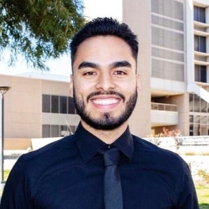
 KHRIS GONZALEZ PEBE
Junior at the University of Southern California
Khris Gonzalez Pebe, a junior at the University of Southern California, is pursuing a Dual Progressive Master of Science in Human Security and Geospatial Intelligence and a Bachelor of Science in Public Policy with a Data Analytics concentration. With a strong foundation in spatial analysis, international security, and policy research, Khris specializes in leveraging GIS, remote sensing, and data science to address illicit trade, humanitarian crises, and conflict dynamics. She currently serves as an Intelligence Analyst Intern at USCENTCOM J2, monitoring illicit Syrian Captagon trades and assessing humanitarian aid disruptions. Previously, she worked as a Summer Research Fellow at Accountability Counsel, enhancing financial complaint databases and conducting bilingual interviews with civil society organizations. Her independent research includes utilizing deep learning-based image classification to track opium cultivation in Afghanistan and analyzing advocacy success rates in Vietnam and Indonesia using R programming. As an Obama-Chesky Voyager Scholar, Khris has received numerous accolades, including the U.S. Geospatial Intelligence Foundation Scholarship. She has also held leadership roles in Delta Phi Epsilon Foreign Service Society, organizing humanitarian service events and career development initiatives. Khris combines her technical expertise and policy acumen to advance human security and geospatial intelligence research.
 LYNDSEY HOFFMAN
Content and Community Engagement Manager, United States Geospatial Intelligence Foundation (USGIF).
Lyndsey Hoffman’s primary role at the Foundation is to support USGIF programming and initiatives including the annual GEOINT Symposium. Lyndsey oversees programs such as the young professional Golden Ticket program and geospatial-related panels and keynote sessions to advance the GEOINT tradecraft. Lyndsey is also a freelance artist and cartographer, and she holds a master’s degree in Geographic and Cartographic Sciences from George Mason University.
 EVELYN KIM, Ph.D.
Senior Research Scientist, HRL Laboratories
Evelyn Kim, Ph.D., is a Senior Research Scientist and a Group Lead at Intelligent Systems Center at HRL Laboratories. She received her PhD degree in the Electrical and Computer Engineering Department from Carnegie Mellon University, MS in Computer Science from Yale, and BA in Computer Science from UC Berkeley.
Her research interests include human-machine teaming, human state sensing, and human factors in cybersecurity.
 CANSERINA KURNIA
Senior Solution Engineer, Esri
In her role as Solution Engineer for Education at Esri, Canserina Kurnia provides technical advice and assistance in advancing GIS and Remote Sensing technology for teaching, research, and campus administration in higher education institutions. She has over 20 years of experience working in field of Geospatial technology (GIS) with extensive experience in location analytics, spatial thinking, desktop, enterprise and web GIS. She is passionate in communicating the latest advancement in Geospatial and Esri technology.
 KATHERINE A. LESTER
Lecturer and Director of Masters Programs
As a medical geographer, she investigates the spatial relationship between suicide, mental illness and race and ethnicity. With a National Science Foundation graduate research fellowship, she developed a novel framework to identify suicide risk among minority populations. Dr. Lester also explores GIS applications to spatial patterns of disease and health. She employs numerous spatial statistical programs to conduct her analysis.
Prior to joining the USC Spatial Sciences Institute, she was at the University of North Texas, where she was a research assistant, collaborating on the production of a book on world regional medical geography and on a project analyzing Uber data to identify changes in traffic and spending associated with the COVID-19 pandemic.
At the University of North Texas, Dr. Lester also was an adjunct faculty member and teaching assistant for courses in world regional geography, geohealth and environmental science.
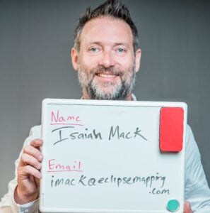
ISAIAH MACK
Owner, Eclipse Mapping and GIS LLC
Isaiah Mack is the owner of Eclipse Mapping and GIS LLC and specializes in high accuracy Eos Arrow GNSS receivers and GIS Mapping. Isaiah has been in the geospatial industry for 18 years since graduating from the University of Southern California in 2002 with an M.S. in Geography and Geographic Information Science and Technology (with a focus on Coastal Geomorphology and GIS). Isaiah also received a B.S. in Environmental Science and Geology at the University of Oregon in 1999. Since his graduation from USC, Isaiah has worked with the USC Graduate Programs in Geographic Information Science and Technology, in particular with the Spatial Data Acquisitions course on Catalina Island.
 DAVE NEFF
Maritime Market Director, Woolpert
An NSPA-THSOA Certified Hydrographer, David Neff serves as Maritime Market Director within Woolpert’s Geospatial sector. He manages hydrographic projects across the United States focusing on Western seaboard and California coastlines, the gulf regions, as well as international projects including the Marshall Islands. Dave is highly skilled in the development of processing workflows for new technology and data management of large volume datasets and has been instrumental in the implementation of autonomous technology in hydrographic workflows since 2015.
Dave has managed and coordinated multiple large scale United States National Oceanic and Atmospheric Administration (NOAA) charting projects with involvement in task order contract negotiation, operations management, vessel mobilization, client correspondence, staff scheduling and management, developing processing workflows, data collection, data processing, QA/QC of hydrographic data, reporting and final data review. Through this effort he completed several nautical charting task orders in the Gulf of Mexico, California, Alaska, and North Carolina for over a decade. He has also completed large to small-scale United States Army Corps of Engineers (USACE) projects with involvement in management, vessel mobilization, survey planning, data collection and processing, report writing and product generation.
 NESTOR NEVAREZ
Masters of Science in Business Analytics student at the University of Redlands
Nestor Nevarez is currently pursuing his Masters of Science in Business Analytics (MSBA) at the University of Redlands. Along with being a student Nestor is also a research assistant working alongside Dr. Sarkar Avijit and Dr. James Pick. Researching the digital divide in the country of Mexico. Nestor is also a full time Reporting Analyst at American Honda, working in the customer support and campaign center utilizing data analysis tools to provide insights and drive continuous improvement initiatives.
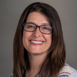 SUZANNE PERLITSH (WECHSLER)
Professor, and Chair of the Department of Geography at California State University, Long Beach (CSULB)
Dr. Suzanne Perlitsh (Wechsler) is a Professor, and Chair of the Department of Geography at California State University, Long Beach (CSULB). She also serves as the Program Director for the CSULB Master of Science in Geographic Information Science (MSGISci). Over the past 25 years she has developed the geospatial curriculum at CSULB and is committed to preparing students for effective entry into the geospatial workforce. Her research explores topics in spatial data uncertainty and how uncertainty resulting from spatial analyses is quantified and responsibly communicated. She earned a Master of Science and Ph.D. degrees in Forest Resources Management from the State University of New York College of Environmental Science and Forestry where she specialized in GIS and watershed hydrology.
 AMANDA RAGO
AI & Data Operations Analyst, Deloitte Consulting LLP
Amanda Rago is an AI & Data Operations Analyst at Deloitte Consulting, working with a government client utilizing GIS, business intelligence and data analysis tools to provide insights, and enable informed decision-making for the client.
 DARREN M. RUDDELL
Professor (Teaching) of Spatial Sciences and Director of Graduate Studies
The overarching focus of Ruddell’s research is climate and society, an expanding area in global change studies, that incorporates socio-ecological interactions across multiple scales of analysis. Ruddell is particularly interested in the dynamic relationship between human development and the modification of native landscapes which are altering physical processes, as witnessed in rising global temperatures and urban heat islands (UHI), and the subsequent impacts that changing environmental systems pose on human health, well-being, and safety and security. Climate and society serves as the point of convergence between Ruddell’s interests and experiences as a scholar and educator in Human Security and Geospatial Intelligence (HSGI) and Geodesign. While HSGI leverages geospatial technologies to monitor and assess when, where, and to what extent a threat (i.e., heat wave, hurricane) is likely to emerge, Geodesign provides the framework to develop and advance alternative design scenarios and/or remediation strategies through discussion and negotiation with relevant stakeholder groups.
Ruddell teaches and develops curricula in the USC Dornsife Spatial Sciences Institute’s HSGI academic programs offered at the undergraduate and graduate level. He has developed expertise in geographic information science and associated technologies to acquire, organize, analyze, model, and visualize spatial data. As an educator, Ruddell seeks to help students develop the critical and spatial thinking skills required to effectively manage and deploy these technologies in diverse scenarios to produce spatially-informed and scientifically sound results. He has been a leader in both developing and applying innovative pedagogical approaches in the fields of HSGI and Geodesign while implementing and advancing the delivery of course content in mixed modalities to increase access and user experience in synchronous and asynchronous settings.
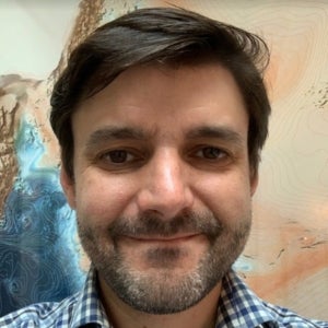
AVIJIT SARKAR, Ph.D.
Professor, Academic Director, Institute for Geospatial Impact, University of Redlands
Avijit Sarkar is Professor of Business Analytics and Director of the Institute for Geospatial Impact (IGI) at the University of Redlands. In his research, Dr. Sarkar studies the adoption and diffusion of information and communications technologies, especially the internet worldwide and their impacts on the creation of mature and inclusive digital societies. He also researches strategic adoption and innovation in the use of geographic information systems (GIS) and location-based technologies in various industries including the private sector. He has co-authored the books Global Digital Divides: Explaining Change (Springer) and Spatial Business: Competing and Leading with Location Analytics (Esri Press). His research has appeared in journals such as Decision Support Systems, Telecommunications Policy, and ISPRS International Journal of Geo-Information. His research has been supported by the University of Redlands Spatial Business Initiative, a unique partnership with Esri, and the U.S. Department of Commerce. He serves on the editorial board of the Journal of Global Information Technology Management. Dr. Sarkar received his Ph.D. and M.S. degrees in Industrial Engineering from The State University of New York (SUNY) at Buffalo. At Redlands, he teaches business analytics and data mining and collaborates with colleagues across disciplines to integrate GIS and spatial thinking across the curriculum.

JOHN P. WILSON, Ph.D.
Founding Director and Professor, USC Spatial Sciences Institute
John P. Wilson, Ph.D., is Professor of Sociology and Spatial Sciences in the Dana and David Dornsife College of Letters, Arts and Sciences at the University of Southern California (USC) where he founded and directs the Spatial Sciences Institute. He also holds adjunct appointments as Professor in the USC School of Architecture, in the USC Viterbi School of Engineering’s Departments of Computer Science and Civil & Environmental Engineering, and the Keck School of Medicine of USC’s Department of Population and Public Health Sciences. He founded the journal Transactions in GIS in 1996 and has served as editor-in-chief since its inception. He has served on the editorial boards of numerous journals and publications, and also served on the board of directors and as president of the University Consortium for Geographic Information Science (UCGIS). He currently leads the UCGIS GIS&T Body of Knowledge 2.0 project and is an active participant in UNIGIS. His research focus is the modeling of environmental systems and makes extensive use of GIS software tools, fieldwork, spatial analysis techniques, and computer models.

CAROLINE WU
Director of Research, placer.ai
Caroline Wu, Director of Research at placer.ai, brings expertise in retail, CRE, entertainment, media, CPG, and tourism, and specializes in synthesizing broad datasets into actionable recommendations for growth. As Director of Research at Placer.ai, she co-authors the weekly Anchor newsletter, represents Placer at conferences, speaks at industry gatherings, and provides consultative services to C-suite clients. She has held positions as the US Director of Consumer Insights at Unibail-Rodamco-Westfield, VP of Retail Insights and Intelligence at Omnicom, and Senior Director at Kantar. She also led research at 20th Century Fox and National Geographic. Caroline holds an MA in Sociology from Stanford University and a BA in International Relations from Stanford University. She currently serves on the USCAA Board of Governors.


