Along the River Route
The following is a first-person account of a research trip to southeastern Peru courtesy of Sarah Feakins, assistant professor of earth sciences at USC Dornsife.
While most tourists travel from Cusco along the Inca trail to Macchu Picchu, our scientific expedition followed a different path downhill with the rivers that leave the Incan highlands. On the eastern flank of the Andes, water flows toward the Atlantic feeding the Amazon River in Brazil.
Our journey followed a major feeder tributary of the Amazon from the high Andes to the Amazonian floodplain within the Cusco and Madre de Dios regions of Peru.
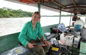
Sarah Feakins, assistant professor of earth sciences at USC Dornsife, assembles the fin of a depth sampler, as well as all the sampling gear on the small boat out of Puerto Maldonado in Southeastern Peru. Photo by Camilo Ponton.
Our research team included Camilo Ponton, a Colombian-born scientist who after receiving degrees in Colombia, Florida and Massachusetts is now a postdoctoral scholar at USC Dornsife, myself and Joshua West, Wilford and Daris Zinsmeyer Early Career Chair in Marine Studies and assistant professor of earth sciences at USC Dornsife. On the expedition, we were accompanied by Valier Galy of the Woods Hole Oceanographic Institution and Arturo Robles of the Universidad Nacional de San Antonio Abad del Cusco.
We followed the river to study the erosive processes that carry Andean sediments and organic carbon down toward the sea. The mission is to understand the balance between the potential energy for inputs in the Andes and the productivity of the cloud forest and rainforests downstream.
Traveling first by truck, we crossed precariously perched gravel roads balanced on top of landslide-prone mountainsides of the Andes. We traced the path of the Kosñipata River from the headwaters in Puna grasslands through the steep slopes of the Andes. Hiking down far below the road, on vertical slopes, our first stop found the team within the debris of a major landslide, something that is common in the wet season. The road trip was punctuated by many more pit stops while Andean road crews repaired the gravel road when sections inevitably were carried off by water, carving the slopes before our eyes. The river flowed gray and dark in the Andes as it flowed tumultuously downstream.
At the mountain front, the river, now called the Alto Madre de Dios, emerges with a roar as its energy releases onto the plains and eventually begins a meandering course through dense jungle. Now the river becomes navigable by motorized canoe. In this canoe, we followed the bends of the river as it coursed through lush rainforest.
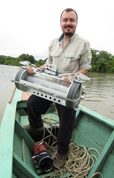
Camilo Ponton, a postdoctoral scholars at USC Dornsife, holds a sampling device that collects water from the river below the surface during a recent research trip in Peru. Photo by Valier Galy.
Along the way, the route was dotted with enclaves of researchers. We traveled more quickly past the numerous gold mining operations along the banks, where it is said that the value of life is less than that of gold, and more quickly still past the tribe of “untouched” Amazonians at Rio Los Amigos that cleared out a rainforest research station after an arrow had struck and wounded a researcher the week before.
Down in the Amazonian floodplain, the rivers ran orange with rainforest soils containing very fine particles called colloids as well as entire tree trunks carried off by the high waters.
Our task was to filter huge volumes of river water, collecting water from deep in the river by day and filtering by night, often through till dawn. We marveled at the sediment load of the waters upstream and increasingly cursed the slow pace of filtering the small colloidal particles that we encountered in the tributaries downstream.
Following the river, the questions we sought to answer were how much sediment and plant matter enters the river, how much makes it out of the mountains, how fast does that plant carbon degrade away and what’s left to travel with the Amazon out to the sea? These questions are all part of understanding the carbon cycle — the balance between the amount of carbon dioxide in the atmosphere and the amount locked up in the earth.
“Rivers hold the key to transport from land to sea, adjusting the carbon budget of the planet,” West said. The carbon that rivers transport out to sea is ultimately sequestered — that is, sealed off from the atmosphere in the sediments under the sea.
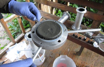
A researcher in Sarah Feakins’ group holds what the team filtered out of the river in the high Andes in Peru. Photo by Camilo Ponton.
After this expedition, which lasted March 8-23, the fieldwork was complete. The next phase of the research involves months of meticulous work in the laboratories at USC Dornsife and Woods Hole Oceanographic Institution in Massachusetts. A smaller team will return to sample the river in the dry season.
“The variability that we observe within the seasons gives us clues to how the system might have changed in the past,” Ponton said.
Understanding that variability, in the largest river system in the world, is a key part of understanding the global carbon and climate balance.