
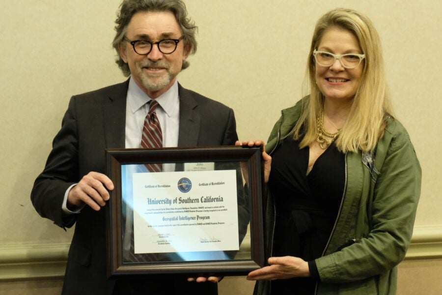
“USGIF accreditation means the USC GEOINT academic programs comply with the highest standards for GEOINT curriculum, faculty expertise, novel research approaches, and availability of adequate resources for state-of-the-art teaching and learning, and is committed to continually improving its program.”
United States Geospatial Intelligence Foundation
What can you do with a BS HSGI?
Meet some HSGI alumni and students

Eric Allen, B.S. Human Security and Geospatial Intelligence ’22
It is not often that you encounter an adolescent boy who would run to maps and geography books instead of the most recent edition of Diary of a Wimpy Kid. Growing up, I would often find myself hyper-focused on maps, the Discovery Channel…

Lindsey Crowe, B.S. Human Security and Geospatial Intelligence ’24
Growing up in the Bronx, I always dreamt of becoming part of something bigger. In 2017, I enlisted in the U.S. Navy and became an Electronics Technician, maintaining Satellite Communications, Radar, and Weapons onboard Naval vessels…

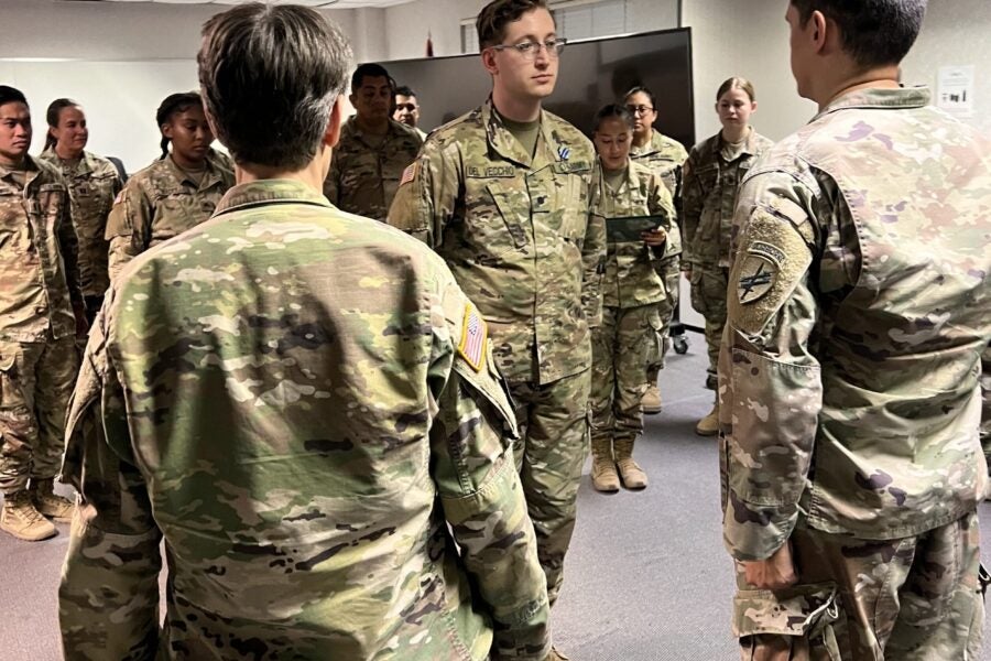
Bluesmon del Vecchio, B.S. Human Security and Geospatial Intelligence; Minor in History ’24
Born and raised in North Hollywood, California, I come from a long line of artists, performers, creators, and clowns (quite literally). This creative upbringing trained me to look at the world in unique ways – always questioning…
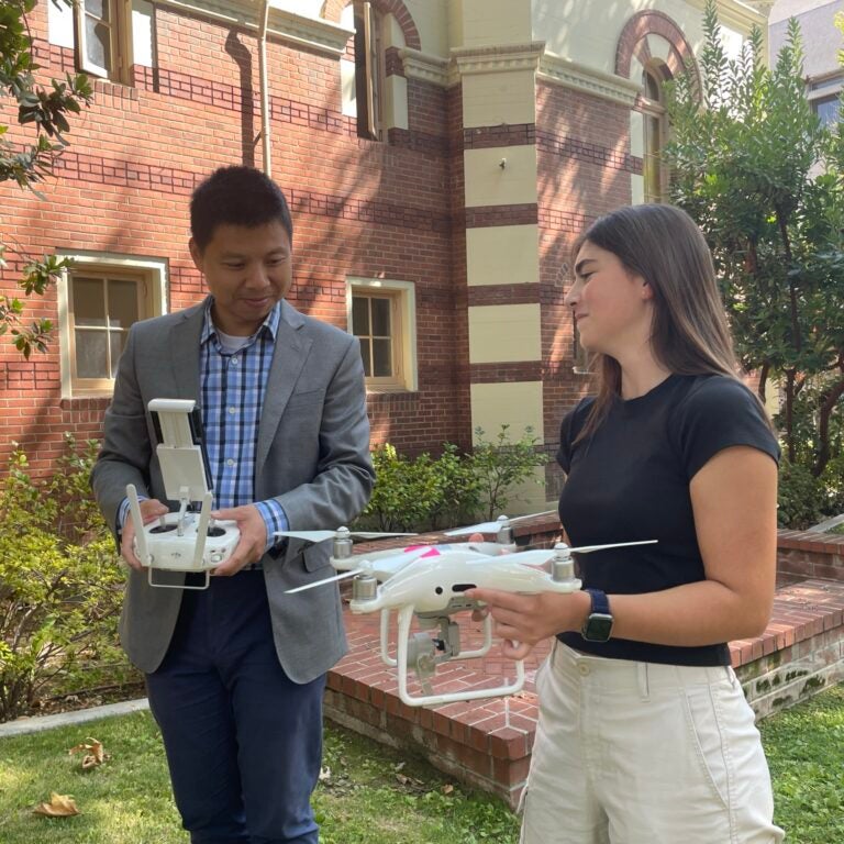
How does a drone collect spatial data?
Dr. Guoping Huang and Dr. Yi Qi demonstrate how it’s done in the field.
“In a recent military exercise, I was able to put what I have learned at the Spatial Sciences Institute into practice! My job in the Army focuses on the interaction between military operations and the civilian population (Civil Affairs). We use geospatial products extensively to understand things like infrastructure systems, demographics and population distribution, and we use those products to assist in planning operations such as large-scale humanitarian aid distribution. During this exercise our unit’s ability to create geospatial products was impacted by limited personnel who had access to training and as part of the stress test some systems broke down. Because of the excellent education I’ve received here at USC, I was able to step up and create multiple maps, overlays and briefings, and train others in the basics of geospatial engineering and analysis on the fly. I am grateful to have been decorated for my efforts with the Army Achievement Medal, and am proud that I could represent the program well!”
— Cadet Bluesmon D. del Vecchio (B.S. Human Security and Geospatial Intelligence and History minor student)
Learning objectives
Explain key concepts from humanities, social sciences, mathematics, and physical sciences, and illustrate the relevance of these disciplines to human security and geospatial intelligence at the intersection of the spatial sciences, international.
Communicate evidence-based ideas and articulate positions orally and in writing.
Apply a variety of digital and online geospatial applications including remote sensing applications and geographic information systems.
Synthesize and analyze information to identify geospatial problems and devise solutions related to human security.
Illustrate how the principles and applications of geospatial intelligence can be used in building healthy, livable and secure communities.
Determine how geographically referenced data can be gathered and organized to support a large number and variety of collaborative projects.
Critique how geospatial data can be visualized, analyzed, and modeled to inform human security and planning, and by doing so, support international and national security requirements.
Analyze how various societies co-exist and evolve in human security settings and how globalization connects near and far-away places and actions.
CURRICULUM
PRE-MAJOR REQUIREMENTS
-
An introduction to the basic tools of statistics. Descriptive statistics; probability; expected value; normal approximation sampling; chance models; tests of significance.
-
Comprehensive introduction to contending theoretical and analytical approaches; development of critical, evaluative, cognitive, and analytical competencies regarding historical and contemporary issues.
MAJOR REQUIREMENTS
-
The focus is intelligence to improve the making of policy, with attention to collection; overt and covert, operations; domestic intelligence; and oversight in democracies.
-
Develops a framework for understanding public policy and its role in solving current complex issues. Theories, processes and institutions that shape policymaking and professional development for policymaking.
-
Introduction to basic geospatial intelligence knowledge and related practical applications that assist in informing decision-making in a variety of human security settings.
-
Introduction to the complex relationship between human development and natural hazards, which are increasingly causing damage and displacement to human populations throughout the world.
-
Develop the requisite knowledge and practical skills to source, analyze, and produce GIS and simulation-based projects with unmanned aerial systems-derived data.
-
Role of maps and spatial reasoning in the production and use of geographic information for representing and analyzing human and environmental activities and events.
-
Conceptual foundations and techniques of statistics and how they can be used with geographic data to produce actionable information across spatial science domains.
-
The various ways in which geography can be used to acquire, represent, organize, analyze, model and visualize information. Laboratories are organized around ArcGIS software suite.
-
Fundamentals of spatial modeling and remote sensing and how to use GIS customization and programming to streamline complex spatial analysis and modeling workflows.
CAPSTONE COURSE
-
Methods for direct observation and recording of the directly experienced built environment through drawing, diagramming, photographing, and writing. The course includes exercises and field experience.
MAJOR ELECTIVES
Choose four courses (16 units)
-
Examination of the ways that different nations and cultures have remembered the Vietnam War or the American War as it is called in Vietnam.
-
Interdisciplinary study of the pursuit of peace, including causes of wars, arms races, conflict resolution, peace movements, nonviolent resistance, and peace with justice.
-
Key concepts in international security studies; historical evolution of international warfare and diplomacy; contemporary international security issues.
-
Basic concepts and analytical approaches in the study of decision-making at the international level. This is a case-based class, requiring participation of students in interactive discussions of decision forcing and retrospective foreign policy cases.
-
Causes and effects of use and spread of nuclear, biological and chemical weapons; responses to WMD, including deterrence, preventive war, and non-proliferation policies and negotiations.
-
Introduction to the natural and cultural diversity of the Middle East through the prism of globalization and sustainability.
-
Modern political ideologies; their assumptions, perceptions, and prescriptions regarding political stability and social injustice: anarchism, communism, socialism, liberalism, conservatism, and fascism.
-
Interaction between law and politics; overview of the American legal system; value conflicts and public policy questions which arise within it.
-
Overview of human rights controversies across the globe. Introduction to techniques of analysis for social issues, interdisciplinary research methods, and interpretation of complex political problems.
-
Cities and the rise of states; globalization and localization; federalism and decentralization; comparative politics of urban regions in developed and developing countries.
-
Understanding human behavior in public organization: motivation, roles, communication; group behavior and decision-making in public context; managing conflict; leadership and change in public complex organizational systems.
-
Contemporary management theory; the nature of complex organizations’ organizational and intergovernmental arrangements; roles and responsibilities of managers; managerial and organizational effectiveness; organizational structure and dynamics.
-
Intensive living-learning research and field experience in Los Angeles and abroad; application of GeoDesign strategies to local societal challenges.
Learn more
-
Ask Dr. Darren M. Ruddell about the B.S. in Human Security and Geospatial Intelligence. Email him at druddell@usc.edu.
-
Candidates for the B.S. in Human Security and Geospatial Intelligence (HSGI) can qualify for graduation with departmental honors:
Eligibility requirements
HSGI majors with cumulative GPA ≥ 3.7 in department courses in their second to last semester and an overall GPA ≥ 3.5.
In addition, to qualify for the honors designation, HSGI majors must complete one or both of the criteria listed below:
- Students present a poster or make a presentation of their research at a venue such as the Provost’s Undergraduate Research Symposium, the Los Angeles Geospatial Summit, or another professional conference; and/or
- Students exhibit leadership within a club or organization (e.g., SC Mappers), serve as a speaker for an academic event, or represent the B.S. in HSGI program in some effective way (e.g. as a student assistant at the USGIF GEOINT Symposium).
Enrollment Process
Eligible and eligible students apply for the HSGI Honors Program by their academic advisor preceding their final semester.
Honors Application
Students are required to submit to the HSGI academic advisor an application package that includes the following items: name, student ID, major, GPA (overall and in the department), current and dated resume, STARS report, and proof of participation for distinction of honors. HSGI majors meeting the GPA and other criteria in their final semester also will be invited to apply in their final semester at the discretion of the HSGI Honors Program evaluation committee.
Evaluation and Designation of Honors Distinction
An HSGI Honors Program evaluation committee–comprised of at least three faculty from the Spatial Sciences Institute or its affiliated faculty–will be formed each year by the Spatial Sciences Institute Director of Undergraduate Studies to identify and assess which applicants will warrant honors.
Honors Designation:
There is not a fixed number of honors designations that can be awarded each year.
B.S. in HSGI students who earn the honors designation will see the designation on their USC transcripts. This honors designation is not printed on diplomas.
-
The USC Progressive Degree Program enables superior USC undergraduates to begin work on a master’s degree while completing requirements for their bachelor’s degree. Students who are admitted to a master’s program with a progressive degree option can complete both their bachelor’s and master’s degrees in five years.
With a progressive degree path, B.S. in Human Security and Geospatial Intelligence could lead to a:
- M.A. in Environmental Studies
- Master of Planning
- M.S. in Geographic Information Science and Technology
- M.S. in Human Security and Geospatial Intelligence
- M.S. in Spatial Data Science
- M.S. in Spatial Economics and Data Analysis
- M.A. in Global Security Studies
Consult the USC Progressive Degree Program information and discuss specific details about your interests and goals with Monica Pan, SSI academic advisor, at monicap@usc.edu.


