Peeling off the Layers
For the first time, an active delamination of continental lithosphere has been found beneath the Colorado Plateau. Meghan Miller, assistant professor of earth sciences in USC Dornsife, and her team’s discovery is featured today in Nature.
“The bottom of lithosphere is actually peeling off,” said Miller, referring to the outermost layer of Earth, comprising the crust and a portion of the upper mantle.
The detachment was detected at between 60 to 200 kilometers — or 37.2 to 124.2 miles — beneath the Earth’s surface in a central-western portion of the Colorado Plateau, a tectonic province covering parts of Colorado, New Mexico, Arizona and Utah. In the past, researchers have imaged delamination structures that had stopped peeling off millions of years ago.
“We think this is the first time we’re actually seeing delamination taking place right now,” she said. “That was the exciting part. We didn’t expect it.”
The lithosphere splitting off into layers may explain why the Colorado River has been incising into the Grand Canyon. Until about 6 million years ago, the river was about 1 kilometer or 0.6 miles higher than it is today. Then, the base level of the Colorado River dropped and the river began to cut the canyon, and base levels for rivers throughout southeastern Utah dropped. For all rivers that drained into the Colorado, rapid incision followed, according to the National Park Service.
“As part of the lithosphere is peeling off, it changes the buoyancy of the lithosphere so that the Colorado Plateau began to be uplifted,” Miller said. “So the Colorado River is actually incising into the Grand Canyon and eroding the rocks faster in that area.”
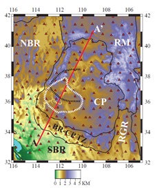
The white dotted circle in the image is the area where USC Dornsife’s Meghan Miller and her team discovered active delamination of the continental lithosphere in the Colorado Plateau. View larger image. Graphic courtesy of Meghan Miller.
Miller and her co-authors believe the delamination event has been active for about 6 million years. It began occurring because the layer beneath the lithosphere — the asthenosphere — contains small amounts of melt, which can generate magmas, a complex high-temperature fluid began to invade the thick lithosphere beneath the Colorado Plateau.
“As the magmatic intrusion infiltrates into the lithosphere it solidifies and changes the density,” she said. “When it changes the density it becomes less buoyant and wants to peel off. So as magma seeps into the lithosphere from the asthenosphere, that causes the little bits of melt that gets into the colder region to solidify. That increases the density, causing it to peel off and drop into the mantle.”
Miller began her Colorado Plateau research two years ago as a postdoctoral student at Rice University. She joined USC Dornsife in 2009 as a structural seismologist in the Department of Earth Sciences. Shortly after this she received funding from EarthScope, a program of the National Science Foundation (NSF) that deploys thousands of seismic, GPS, and other geophysical to study the structure and evolution of the North American continent.
“I use data from earthquakes that happen on the other side of the world,” she said. “Like the ones we recently had in Japan and New Zealand. I record these data with seismometers and study the way the seismic waves travel to the other side of the Earth in order to image the structure beneath the Colorado Plateau. Imaging the Earth is similar to a Cat Scan.”
Now, Miller and her colleagues are searching other regions for possible active delamination.
“With the EarthScope program,” she said, “we have more data than has ever before been available.”
Read the abstract online. The full article is available to Nature subscribers.