Unshaken: USC earthquake scientists race to the scene of temblor
After a 6.4 magnitude earthquake struck near Ridgecrest, California, on July Fourth, Christine Goulet packed her bags and headed for an area near the epicenter of the Searles Valley Quake.
On July 5, after a long day of investigation, she and her fellow engineers and scientists were discussing where to eat dinner when a 7.1 magnitude quake struck the same area.
For Goulet, tremors are a call of duty. She is an earthquake researcher and the executive director for applied science at the Southern California Earthquake Center (SCEC) at USC Dornsife College of Letters, Arts and Sciences. The center is a coalition of more than 1,000 earthquake experts worldwide from 75 institutions. Much of the research by SCEC scientists is supported by the National Science Foundation and the U.S. Geological Survey (USGS), the lead federal agency on earthquake monitoring and response. SCEC’s research is also utilized by national and state organizations.
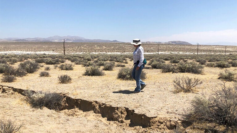
Like a squadron of forensic investigators descending on a crime scene, teams of geologists, seismologists and engineers race to the epicenter after a quake occurs in California to analyze how much the faults shifted and to assess what it means for the region. Goulet is part of the Geotechnical Extreme Event Reconnaissance (GEER) team that looks at earthquake effects such as “ground failure”— that includes, in addition to the fault displacement itself, signs that the soil beneath amplified the shaking or liquified, causing lateral spread during the quake.
Goulet’s GEER team is among several that share data with the California Earthquake Clearinghouse, a statewide databank of images, measurements, graphics, maps and other records made by scientists in the wake of a quake. The clearinghouse receives, curates and shares the data with other researchers, as well as state and regional officials. The scientists and engineers in the field often turn to the clearinghouse to compare data, or to fill in gaps in their own observations and measurements.
Race against earthquake tourists
Timing is everything. Scientists and engineers are trying to gather as much perishable information as they can before another quake — or earthquake tourists roam the site.
Earthquake tourists can — and did in Searles Valley last week — descend on the hardest-hit areas. Near the town of Trona, they tromped across faults and cracks, taking selfies and photos and marring the scientists’ chances for precise measurements that would otherwise inform them how much the faults had shifted.
“We try to measure how much the faults move laterally and vertically,” Goulet says. “This land is basically desert, though, with very dry soft soil. Tourists sometimes walk over the cracks, not knowing how important it is for us to measure them.”
Even so, Goulet and her team were able to find some interesting evidence of “lateral spreading” — a type of ground failure in which the soil liquifies and the harder crust on top of it moves during a quake.
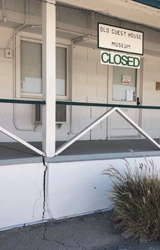
A museum in Trona, California, suffered major cracks in its structure caused by soil shifts wrought by last week’s earthquake double-whammy. (Photo: Christine Goulet.)
The information that the scientists uncover and share with the California Earthquake Clearinghouse can also record damage or potential problems with infrastructure such as buildings, roads, gas pipelines, electrical lines and water lines.
“We have a photo gallery and data map, and a resources library,” says Maggie Ortiz-Millan, a program manager for the Earthquake Engineering Research Institute that helps to oversee the clearinghouse. “Having that data means that researchers can cover more ground. It can also mean that evidence of rupture or damage to roads or pipelines can (then) get repaired quickly.”
In support of rapid response
The clearinghouse, which dates back to 1972, is set up every time a large quake occurs to ensure researchers quickly gather and share their findings with each other and state agencies that need the information for emergency response and planning. The clearinghouse is a consortium of five agencies: California Geological Survey, California Office of Emergency Services, California Seismic Safety Commission, Earthquake Engineering Research Institute, United States Geological Survey.
USC Dornsife earthquake scientists and SCEC scientists are among several researchers who contribute data to the clearinghouse.
After a quake, the clearinghouse acts as an operations hub, enabling the scientists and engineers to connect with one another and to trade information. It hosts nightly telephone briefings with the researchers and state geological and emergency officials until scientists have exhausted their reconnaissance efforts.
Goulet says the clearinghouse provides a valuable service that makes a difference in rapid, efficient earthquake response. “Different groups coordinate and share valuable information, pointing each other to location of interest for each other’s disciplines and sometimes sharing resources and equipment.
“From an engineering perspective, we want to not only understand earthquakes for science’s sake, but also to really help build a better, more resilient society,” Goulet says. “That involves having better data to constrain all of our models, equations or simulations, and that will help us fill in the gap on what we can expect from the future.”
You and your friends, family and co-workers can better prepare to survive and recover from future earthquakes through the Seven Steps to Earthquake Safety and by participating in Great ShakeOut Earthquake Drills. USC participates annually in ShakeOut and has done so since ShakeOut began in 2008.