USC Dornsife introduces new minor in human security and geospatial intelligence
How often do you think about human security?
Human security can be threatened by natural disasters — earthquakes, hurricanes and floods — as well as human actions such as terrorism, humanitarian crises and warfare. As our global society becomes more interconnected, government agencies, scholars and international decision makers must have the knowledge and capacity to quickly assess and act to provide humanitarian aid in a crisis situation.
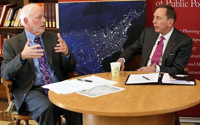
Gen. (Ret.) David Petraeus, a Judge Widney Professor at USC and former CIA director, visited the University Park campus this month for a number of events including a special roundtable discussion focused on geospatial intelligence, or GEOINT, and its role in optimizing human security. Other panelists included Steven Lamy, vice dean for academic programs and professor of international relations; Michael Orosz, assistant director of the USC Viterbi School of Engineering’s Information Sciences Institute; and Col. (Ret.) Steven Fleming, professor of the practice of spatial sciences.
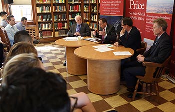
Panelists at the Nov. 3 roundtable event. Photo by Mike Glier.
GEOINT is information about human activity on earth that is derived from the analysis of maps, imagery and other location-specific data. It has become increasingly important both in terms of national security and for global humanitarian, public health and disaster response efforts.
At the event, Petraeus spoke in the context of the U.S. military and its exploitation of GEOINT to address national security threats. The panel talked about how the ability to map and understand “human terrain,” including social and cultural knowledge that can be layered over geospatial data, creates a powerful fusion of intelligence that helps us keep pace with changing geopolitical landscapes.
“GEOINT is enabling a true transformation in how we are fighting terrorists around the world,” Petraeus said. “This is revolutionary stuff.”
Putting learning to use right out of the gate
Responding to this growing phenomenon, USC Dornsife’s Spatial Sciences Institute (SSI) launched a new interdisciplinary minor in Human Security and Geospatial Intelligence this Fall. The program is designed to educate future leaders in location-based analytics and provide a framework for students wanting to learn how to develop cutting-edge geospatial solutions to global challenges.
“We wanted to create a major or minor in something that undergraduates could use right out of the blocks in their professional world,” said Fleming, one of the key developers of the minor program.
The minor complements majors in international relations, political science, environmental studies, majors studying global regions and geodesign. It is also highly applicable to cadets of various majors in USC’s ROTC commands. Fleming, who served for 30 years as an officer in the U.S. Army and now serves on USC’s military affairs committee, said that this material will be immediately useful to ROTC students as newly commissioned officers starting their service.
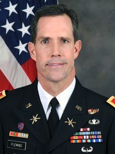
Col. (Ret.) Steven Fleming, professor of the practice of spatial sciences.
For other students, such as those interested in working at the U.S. State Department, for example, or those wishing to round out what they’re learning in other academic majors, Fleming said the minor will further contextualize many of the global issues they’re learning about.
Unique in academia
Apart from the curricula at the U.S. service academies, there are no comparable majors or minors at other American research universities.
Wayne Sandholtz, John A. McCone Chair in International Relations and professor of international relations and law, is enthusiastic about the new minor.
“It is a terrific opportunity for students to apply advanced data skills to some of the world’s most urgent challenges, including hunger, climate change, pandemics, armed conflict and more,” he said. “I wish I could enroll.”
Sophomore Robert Smith, an international relations major and ROTC cadet, signed up for the minor this semester. He plans to commission as a U.S. Army officer after graduating.
“GIS [geographic information system] technology is really revolutionizing the way we do a lot of things in the context of law enforcement and the military — how we collect and analyze intelligence,” he said.
He was drawn to a degree program that reinforces this knowledge and builds the related skill set.
“[The minor has] upper-division IR classes on terrorism, espionage and intelligence. There’s concrete crossover between my minor and my major; it’s augmenting what I know about IR and tempering it with knowledge of technology that can be used to analyze information through a geographical perspective.
“I think my minor is going to be at least as beneficial as my major when I’m in the Army.”
Petraeus praised SSI and the university for its trailblazing academic programs.
“Kudos to SSI, a very impressive initiative at USC,” he said. “It’s another area in which USC is ‘walking point’ for a particular endeavor in the academic world and bringing various disciplines together as well. It’s truly cutting-edge technology.”