Dutch Lessons on GeoDesign
With a GoPro camera strapped to the front of her bicycle, Nicole Bosetti rode through the streets of Amsterdam. Whirring past brick-front cafes and canals, she captured footage of the safe and efficient bike paths available to cyclists. In Amsterdam, bicycles outnumber the residential population of about 800,000. With more than 250 miles of road dedicated to cyclists, biking is a popular and efficient method of transportation. In fact, it’s a deeply valued part of Dutch culture.
Bosetti, a GeoDesign major at USC Dornsife, encountered protected bike lanes, which separated cyclists and drivers with physical dividers, and a dedicated set of traffic signals for bicycles. She wondered, “How can we make Los Angeles more bike-friendly?”
Student Morgan Link tests out the Phoenix touch table, cutting-edge spatial technology that allows spatial science professionals and community members to provide input on the same project. In Amsterdam, students visited Geodan, a geo-information and technology firm that designed the Phoenix. Photo courtesy of Darren Ruddell.
“Right now, about one percent of commuters in Los Angeles ride bikes to work,” Bosetti said, noting that with 87 percent of L.A. County roads at less than a 5 percent grade — meaning they’re mostly flat — the city is ideal for cycling. Increasing the number of bike commuters in L.A. could ease the city’s notorious traffic, cut down on fossil fuel dependence and get residents exercising.
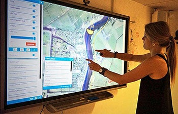
Student Morgan Link tests out the Phoenix touch table, cutting-edge spatial technology that allows spatial science professionals and community members to provide input on the same project. Photo courtesy of Darren Ruddell.
Using strategies she learned in Amsterdam, she presented a proposal to her classmates in the Problem’s Without Passports (PWP) class “GeoDesign Practice: The European Experience.”
Led by Darren Ruddell, assistant professor of spatial sciences, students in the course spent two weeks in the Netherlands in June, touring various cities and meeting with experts to learn about urban planning techniques, geospatial technologies and environmental design strategies.
The Dutch have a long history of thoughtful city planning, which is a matter of survival, Ruddell explained. With 25 percent of the country under sea level, the Dutch had to find a way to utilize their natural landscape.
“They figured out a way to pump out water to use their land, and they have become extremely successful and sophisticated at developing systems that create harmony between ecological and human systems,” Ruddell said.
The students’ goal was to use what they learned from Dutch geodesign — the interdisciplinary field of spatial science, architecture and planning — and apply it to a design challenge in Los Angeles.
“Geodesign is about providing a better living environment,” Ruddell said. “Cities can have a profound footprint on the environment, or there are cities that tread more lightly, so to speak, on the natural landscape. Ultimately, it’s about finding a way to balance human and environmental systems.”
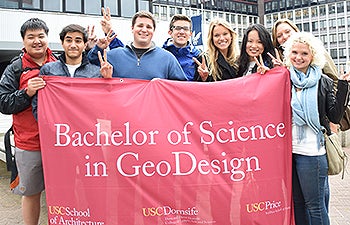
Students in the Problems Without Passports class “GeoDesign Practice: The European Experience” say “Fight on!” from Amsterdam. Photo courtesy of Darren Ruddell.
In their research, students visited the medieval city of Utrecht and the master-planned community of Almere, the latter built 40 years ago to provide a sustainable alternative to dense, urban Amsterdam. In Almere, they visited the International New Town Institute, a think tank dedicated to improving the quality of global urban development. In Rotterdam, they attended a professional conference on urban sustainability and vitality.
Students also met with faculty from Vrije University (VU) Amsterdam to produce a case study on the Amstelland region just south of Amsterdam. Their mission was to make a case for why the region should be nominated as a UNESCO World Heritage site, a distinction recognizing locations of universal value worldwide, and propose how to create an interactive experience for visitors once that status has been granted.
First touring the region by bicycle, students then spent three days at the university crafting proposals for how they visualized the future of Amstelland.
“Students proposed incorporating efforts to engage K–12 students and teachers in Holland with hands-on projects to learn about environmental conservation and landscape design, as well as human health and exercise,” Ruddell said. “Another proposed idea was to repurpose historic estates near the heritage site into bed and breakfast facilities or art studios to serve as information centers and sites for aspiring artists, which will help provide jobs and stimulate economic activity.”
GeoDesign major Serhan Ülkümen said studying at the research university in Holland complemented the hands-on experience.
“Biking around the area whose future we would spend three days creating our vision for was vital,” said Ülkümen, who is also majoring in media arts at the USC School of Cinematic Arts.
After all, one of the most crucial stakeholders in any city planning project is the residents who live there, said Morgan Link, a policy, planning and development (PPD) major at the USC Sol Price School of Public Policy.
“Going out in the field, you get a firsthand look at the culture,” Link said. “You realize all of the different factors that make up a city and its identity. That’s something you can’t get from a text book.”
Students also met with geodesign professionals at Geodan, a geo-information and analysis technology firm based in Amsterdam. They received a demonstration of Geodan’s cutting-edge spatial technology, the Phoenix touch table. The tablet, which is the size of a table, allows spatial science professionals and community members to provide input on the same project.
“The entire purpose of the Phoenix table is to better connect the community with officials on a particular project,” Bosetti said.
Interactions such as these informed students’ final projects proposing new ways to approach societal challenges in L.A. using geodesign techniques they learned about in the Netherlands. In addition to Bosetti’s suggestions for building out L.A.’s bike infrastructure, students’ plans included methods for increasing urban gardens, redeveloping the Los Angeles River and cultivating the city’s digital infrastructure, for example increasing wireless internet access points.
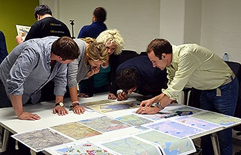
Working with faculty from Vrije University in Amsterdam, students helped produced case studies proposing why the Amstelland region of Holland should gain UNESCO World Heritage status. Here, they look at maps as they craft proposals for how they visualize the future of Amstelland. Photo courtesy of Darren Ruddell.
GeoDesign major Eleanor Ouyang’s proposal focused on improving the pedestrian experience in L.A. She noted that in L.A., most pedestrians walk on pavement — which is not ideal in a warm climate — with little or no signage pointing out major landmarks.
Her recommendations were to increase grass and trees along pathways, provide more barriers between pedestrians and traffic, and create more signage pointing out historic landmarks.
Bosetti’s final recommendations included incorporating elements of Amsterdam’s engineering and design to create safer streets for cyclists in L.A. Right now, she noted, the majority of bike lanes in L.A. position riders between traffic and parked cars, a dangerous combination.
“In L.A. we need to redefine what a safe bike lane is,” Bosetti said, suggesting the idea of creating buffers between cars and cyclists as they do in Amsterdam.
“In Amsterdam, there’s not much room on the streets, but they make it work,” she said.