Shaking it up in Morocco
The dusty Land Cruiser bumped and rumbled along the Moroccan desert floor as our caravan approached the village of Merzouga under the light of a waxing moon.
A long day of travel behind us, the dunes in the distance were looming larger, indicating that soon our rigorous fieldwork would begin.
This May, I traveled to Morocco with four other undergraduates, one graduate student and one postdoctoral researcher as a part of USC Dornsife’s earth science Maymester course, “Field Geology,” taught by Meghan Miller, assistant professor of earth sciences. The goal of the course was to investigate the tectonic evolution of Morocco by using modern seismological data.
Classes met a few times during the Spring semester, then we took off for Morocco and a seismological field experience of a lifetime. The trip began with a long day of travel to our starting point in Marrakesh. During the 10-day research trip, we made a loop through much of Morocco, crossing from coastal regions through the mountains, to the desert and back again. From the sandy expanse of the Sahara desert to the towering peaks of the Atlas Mountains, Morocco is certainly a place of topographic extremes.
Our trip involved an ongoing geophysical study. Since 2009, as part of the PICASSO (Program to Investigate Convective Alboran Sea System Overturn) initiative, an internationally collaborative scientific endeavor, professor Miller and her team have been responsible for a portion of 105 seismometers deployed throughout rural Morocco, away from city noise. Now that it’s 2013, it was time to remove the earthquake monitoring equipment, collect our data and prepare the apparatus for customs in its travels back to the United States.
For our course, each of us was tasked to better understand a specific aspect of Morocco’s complex geologic history. We also learned about the sensitive scientific equipment that we were using in the field.
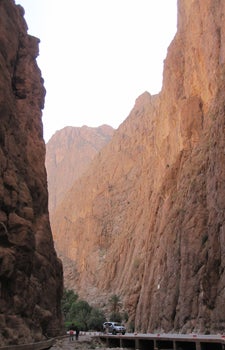
With their limestone walls rising a few thousand feet above them, student were awed by the magnificent rusty orange Todra Gorges seen here. Photo courtesy of Meghan Miller.
For the first leg of our journey, local structural geologist and geophysicist Driss Elouai guided us to prominent geologic outcrops and vantage points to help us develop a broad, contextual understanding of the tectonic and geologic history of Morocco. We saw structural evidence for the tectonic reversal responsible for the uplift of the tallest mountains of Morocco. And we saw Bou-Azzer ophiolite — a large section of rocks thought to represent oceanic crust.
With their limestone walls rising a few thousand feet above us, we were all impressed by the cracked, rusty orange Dadès Gorges and Todra Gorge.
After Merzouga we began our fieldwork, and this was perhaps the most valuable part of the trip — academically and culturally. The instruments we use are very sensitive to any kind of ground motion, so to get the best quality data, the equipment must be implemented away from sources of noise like traffic, people, animals and wind. Therefore, we traveled to many rural areas in a diverse range of topography.
From sandy deserts to mountain meadows, we visited small towns away from any sort of tourist attraction and had the opportunities to see how many native Moroccans have lived for centuries.
Interacting mostly with farmers and shepherds, we were often invited into their adobe homes to share traditional Maghreb mint tea, round flatbread (khobz), fresh scrambled eggs and goat-milk butter. Although the language barrier was wide, our drivers and Driss translated conversations. But no words were needed to comprehend the open arms and smiles from the friendly locals.
Most were excited that we were so interested in their North African homeland, and I gained a far-stronger appreciation for the opportunities I have had growing up in the “Western” world. I have always found geology exciting for its fieldwork opportunities — the chance to escape the city and explore someplace new.
In broad terms, geology as a science can be reduced to a study of the planet Earth. In this course, I learned a variety of new technical skills increasing my scope of knowledge within my field. And perhaps more important, I was given the chance to explore a part of this world so different than my own. This has given me a greater appreciation of the diversity of people and cultures that, like the massive slabs of solid rock we study as geologists, also make up planet Earth.
Christopher Norwood is a senior earning his B.S. in geology at USC Dornsife. He grew up in Fallbrook, Calif., a small town in north San Diego County. An avid traveler and rock climber, he is currently spending a semester abroad studying at the University of Cape Town, South Africa, continuing along a path that combines his academics with exciting, new cultural experiences.