Keeping a Promise
Andrew Curtis is a man of his word.
When he left Louisiana, friends asked point blank if he was going to desert them. “USC offered me a position in 2006, but I delayed a year to continue my post-Katrina disaster recovery work in New Orleans,” he said.
Every six months, Curtis returns to New Orleans accompanied by former and current students of “Natural Disasters,” a general education course he teaches in USC College.
Curtis began walking the streets of New Orleans neighborhoods during the first week of October 2005, witnessing firsthand the depths of the disaster. “I participated as a member of the Louisiana State University Geographic Information Systems Team, which supported operations in the state’s Emergency Operations Center during the response to Katrina.
“One of my graduate students wanted to get a boat and be in the midst of the disaster, to physically put a hand on a person and to personally facilitate a rescue,” he said. “But I explained to him that he had the ability to create a map that could potentially save 15 people.”
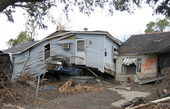
Buildings in the Lower Ninth Ward following Hurricane Katrina. Photo credit Andrew Curtis.
Probably everyone at LSU at the time knew someone directly affected by Hurricane Katrina, one of the five deadliest hurricanes and the costliest natural disaster in United States history. He continues to feel a shared sympathy as an assistant professor of the practice of American studies and ethnicity in the College.
While teaching at LSU in Baton Rouge, Curtis began a first-of-its-kind project that uses a spatial video system that connects cameras fastened to an SUV to a central global positioning system.
“Our efforts focus on the neighborhoods hit the hardest by Katrina, such as Holy Cross, Hollygrove and especially the Lower Ninth Ward, which still has less than one quarter of its pre-Katrina population,” Curtis said. “We drive street by street documenting the still-startling devastation that remains along with the evidence of progress.”
Traci Auer ’11, a mathematics and economics double major, and Bashar Badran ’11, a biological sciences major, are part of Curtis’ team and both have made two trips to New Orleans.
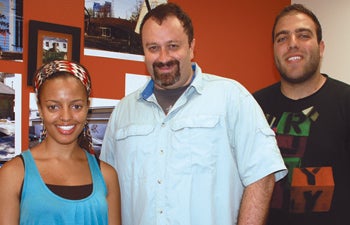
USC College’s Andrew Curtis (center), Traci Auer ’11 (left) and Bashar Badran ’11 are documenting the rebuilding process in New Orleans, particularly in the Lower Ninth Ward following Hurricane Katrina. The first-of-its-kind project uses a spatial video system that connects cameras fastened to an SUV to a central global positioning system. Photo credit Mira Zimet.
“I knew several people who were evacuated, and I was on the phone with a few of them at the time,” Auer said.
“This type of video mapping work is cutting-edge and no one else is doing it,” Badran said. “Although I did not know anyone directly affected by Katrina, I helped out knowing that our work would benefit those in need.”
Members of the community ride along with Curtis and his students to provide commentary on what was and what is. “They offer a critical historical component to our project,” he said. “These individuals help us tell the New Orleans story, along with other key people including church ministers,” he said. In return, the maps that are created are given back to the neighborhoods to help with planning and grant applications.
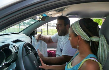
After setting up their spatial video equipment, Auer and Badran determine their data collection route in New Orleans. Photo credit Royce Wells.
Curtis described the water in the Lower Ninth Ward as having reached 15 to 16 feet as gauged by the marks on the buildings. “We would have to walk ahead to check out the conditions of the roads, and many were impassable,” Badran said. “The potholes were so deep that we were afraid we were going to break an axle.”
The videos tell an amazing story of desolation, depression and despair. Structures are flattened; vegetation is overgrown and buildings hauntingly stand in ruin; even five years later. “Signs of hope and rebuilding exist, also,” Curtis explained. “It will take years to get the city back to where it once was, but some culturally rich places such as the Lower Ninth Ward will never be the same again.”
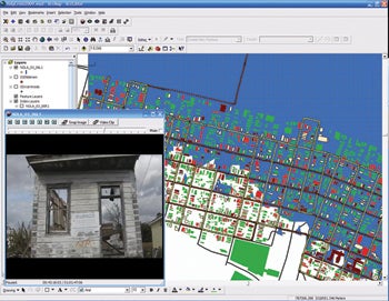
The spatial video route displayed in a geographic information system.
Curtis advocates for neighborhood plans with a more geographically systematic approach to rebuilding. He is concerned about the ongoing stress placed on returnees who still live next to or across from blighted buildings. “In certain neighborhoods, for instance in Holy Cross, some people have Katrina-damaged homes on both sides, and across the street. This situation hasn’t changed over the last few years and eventually it must have a toll.”
“Actor Brad Pitt’s Make It Right Foundation has got it right,” Curtis said. “They are constructing homes systematically from one corner of the Lower Ninth Ward, in effect reestablishing a community as much as rebuilding homes.”
A forward thinker, Curtis aims to predict where the next rounds of health or stress problems may emerge. “We can use the maps we generate from these spatial video runs to not only provide data for community groups seeking grants, but also as a tool to spatially prioritize future rebuilding, and to identify where returnees are most likely to need emotional support based on the physical conditions surrounding them.”
The ongoing work of Curtis has not gone unnoticed. The front page of The New York Times’ fifth anniversary online coverage package featured video documentation and audio by Curtis and his students. “The video segments show the benefit of what we are doing and visually demonstrate why our work is integral to the rebuilding process,” Curtis said.
Read more articles from USC College Magazine’s Fall 2010/Winter 2011 issue