Why Do the Caribbean Islands Arc?
The Caribbean islands have been pushed east over the past 50 million years, driven by the movement of the Earth’s viscous mantle against the more rooted South American continent, new research by geophysicists in USC Dornsife has revealed.
The results, published Aug. 20 in Nature Geoscience, provide a better understanding of how continents resist the constant movement of the Earth’s plates — and what effect the continental plates have on reshaping the Earth’s surface.
“Studying the Earth’s deep interior provides insights into how the Earth has evolved into its present form,” said Meghan Miller, assistant professor of earth sciences in USC Dornsife, and the paper’s lead author. “We’re interested in plate tectonics, and the southeastern Caribbean is interesting because it’s right near a complex plate boundary.”
Miller and Thorsten Becker, associate professor of earth sciences in USC Dornsife, studied the margin between the Caribbean plate and the South American plate, ringed by Haiti, the Dominican Republic, Puerto Rico, and a crescent of smaller islands including Barbados and St. Lucia.
But just like the first law of ecology (and time travel), when it comes to the Earth, everything is connected. So to study the motion of the South American continent and Caribbean plate, the researchers had to first model the entire planet — 176 models to be exact, so large that they took several weeks to compute at the USC High Performance Computing Center.
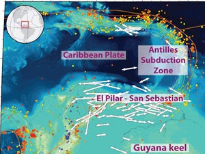
Using earthquake data, USC Dornsife earth scientists model the movement of the Earth to a depth of 3,000 kilometers and provide new insights into the strength of continents. Shown here is a tectonic map of the southeastern Caribbean. Image courtesy of Meghan Miller and Thorsten Becker.
For most people, earthquakes are something to be dreaded. But for Miller and Becker they are a necessary source of data, providing seismic waves that can be tracked all over the world to produce an image of the Earth’s deep interior similar to a CT scan. The earthquake waves move slower or more quickly depending on the temperature and composition of the rock, and also depending on how the crystals within the rocks align after millions of years of being pushed around in mantle convection.
“If you can, you want to solve the whole system and then zoom in,” Becker said. “What’s cool about this paper is that we didn’t just run one or two models. We ran a lot, and it allowed us to explore different possibilities for how mantle flow might work.”
Miller and Becker reconstructed the movement of the Earth’s mantle to a depth of almost 3,000 kilometers, upending previous hypotheses of the seismic activity beneath the Caribbean Sea and providing an important new look at the unique tectonic interactions that are causing the Caribbean plate to tear away from South America.
In particular, Miller and Becker point to a part of the South American plate — known as a “cratonic keel” — that is roughly three times thicker than normal lithosphere and much stronger than typical mantle. The keel deflects and channels mantle flow, and provides an important snapshot of the strength of the continents compared to the rest of Earth’s outer layers.
“Oceanic plates are relatively simple, but if we want to understand how the Earth works as a system — and how faults evolved and where the flow is going over millions of years — we also have to understand continental plates,” Becker said.
In the southeastern Caribbean, the interaction of the subducted plate beneath the Antilles islands arc with the stronger continental keel has created the El Pilar-San Sebastian Fault, and the researchers believe a similar series of interactions may have formed the San Andreas Fault.
“We’re studying the Caribbean, but our models are run for the entire globe,” Miller said. “We can look at similar features in Japan, Southern California and the Mediterranean; anywhere we have instruments to record earthquakes.”
The research was funded by two National Science Foundation CAREER grants.